Talty geodata
Talty (Texas) is a populated place; located in United States in America/Chicago (GMT-5) time zone. With population of 1,927 people, there are 12162 cities with bigger population in this country. Compared to other cities in United States, 86.5% of cities are located further ↑North; 74.2% of cities are located further →East and 63.1% of cities have higher elevation than Talty. Note1


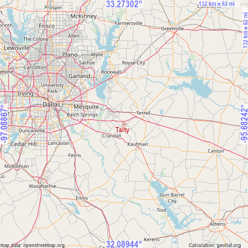
Talty GPS coordinates[2]
32° 40' 59.484" North, 96° 23' 7.944" West
| Map corner | latitude | longitude |
|---|---|---|
| Upper-left | 33.27302°, | -97.08867° |
| Center: | 32.68319°, | -96.38554° |
| Lower-right: | 32.08944°, | -95.68242° |
| Map W x H: | 131.6×131.6 km | = 81.8×81.8mi |
| max Lat: | 71.29058° ⇑86.5% North |
| Talty: | 32.68319° |
| min Lat: | ⇓13.5% South 19.06759° |
| min Long | Talty | max Long |
| -171.73463° | -96.38554° | -66.98998° |
| W 25.8%⇐ | ⇒74.2% E |
Elevation
Elevation of Talty is 138 m = 453 ft, and this is 156.8 m = 514 ft below average elevation for this country.
| Max E: |
3189 m = 10463 ft | 63.1% |
| Avg. | 294.8 m = 967 ft | |
| Talty | 138 m = 453 ft | |
Min E: |
-60 m = -197 ft | 36.9% |
See also: United States elevation on elevation.city.
Geographical zone
Talty is located in North temperate zone (between Tropic of Cancer and the Arctic Circle). Distance of this Northern Tropic circle is 1028.1 km =638.8 mi to South.| Distance of | km | miles | from Talty |
|---|---|---|---|
| North Pole | 6373 | 3960 | to North |
| Arctic Circle | 3767.1 | 2340.8 | to North |
| Tropic Cancer | 1028.1 | 638.8 | to South |
| Equator | 3634 | 2258.1 | to South |


Nearby cities:
15 places around Talty: (largest is in red/bold)
• Combine
15.6 km =9.7 mi,  227°
227°
• Crandall
9 km =5.6 mi, 226°
• Elmo
21.1 km =13.1 mi,  78°
78°
• Forney
10.8 km =6.7 mi,  311°
311°
• Heath
19 km =11.8 mi,  333°
333°
• Kaufman
12.7 km =7.9 mi,  145°
145°
• McLendon-Chisholm
17.7 km =11 mi,  1°
1°
• Oak Grove
17.6 km =10.9 mi,  159°
159°
• Oak Ridge
11.9 km =7.4 mi,  103°
103°
• Post Oak Bend City
8.8 km =5.5 mi,  130°
130°
• Scurry
18.3 km =11.4 mi,  178°
178°
• Seagoville
15.1 km =9.4 mi,  251°
251°
• Sunnyvale
20.7 km =12.9 mi, 307°
• Terrell
11.9 km =7.4 mi,  60°
60°
• Travis Ranch
15.7 km =9.8 mi, 328°
Sources, notices
• [Note1] Compared only with cities in United States existing in our database
• [Src1] Map data: © OpenStreetMap contributors (CC-BY-SA)
• [Src2] Other city data from geonames.org with taken over terms of usage.
• [Src3] Geographical zone / Annual Mean Temperature by Robert A. Rohde @ Wikipedia
