Oakwood geodata
Oakwood (Texas) is a populated place; located in United States in America/Chicago (GMT-5) time zone. With population of 516 people, there are 20683 cities with bigger population in this country. Compared to other cities in United States, 89.4% of cities are located further ↑North; 73.1% of cities are located further →East and 72.3% of cities have higher elevation than Oakwood. Note1


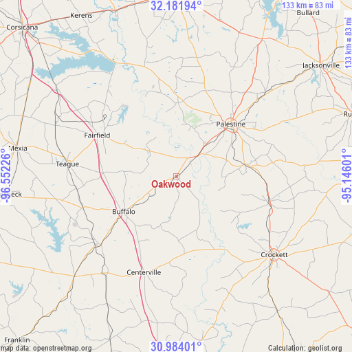
Oakwood GPS coordinates[2]
31° 35' 5.64" North, 95° 50' 56.868" West
| Map corner | latitude | longitude |
|---|---|---|
| Upper-left | 32.18194°, | -96.55226° |
| Center: | 31.5849°, | -95.84913° |
| Lower-right: | 30.98401°, | -95.14601° |
| Map W x H: | 133.2×133.2 km | = 82.8×82.8mi |
| max Lat: | 71.29058° ⇑89.4% North |
| Oakwood: | 31.5849° |
| min Lat: | ⇓10.6% South 19.06759° |
| min Long | Oakwood | max Long |
| -171.73463° | -95.84913° | -66.98998° |
| W 26.9%⇐ | ⇒73.1% E |
Elevation
Elevation of Oakwood is 87 m = 285 ft, and this is 207.8 m = 682 ft below average elevation for this country.
| Max E: |
3189 m = 10463 ft | 72.3% |
| Avg. | 294.8 m = 967 ft | |
| Oakwood | 87 m = 285 ft | |
Min E: |
-60 m = -197 ft | 27.7% |
See also: United States elevation on elevation.city.
Geographical zone
Oakwood is located in North temperate zone (between Tropic of Cancer and the Arctic Circle). Distance of this Northern Tropic circle is 906 km =563 mi to South.| Distance of | km | miles | from Oakwood |
|---|---|---|---|
| North Pole | 6495.2 | 4035.9 | to North |
| Arctic Circle | 3889.3 | 2416.7 | to North |
| Tropic Cancer | 906 | 563 | to South |
| Equator | 3511.9 | 2182.2 | to South |


Nearby cities:
15 places around Oakwood: (largest is in red/bold)
• Buffalo
23.9 km =14.9 mi,  235°
235°
• Center
55.2 km =34.3 mi,  261°
261°
• Centerville
38.4 km =23.9 mi,  198°
198°
• Cooper
45.7 km =28.4 mi,  146°
146°
• Crockett
47.6 km =29.6 mi,  128°
128°
• Elkhart
25.9 km =16.1 mi,  80°
80°
• Fairfield
33.7 km =20.9 mi,  297°
297°
• Frankston
61.3 km =38.1 mi,  31°
31°
• Grapeland
36.6 km =22.7 mi,  106°
106°
• Hickory Creek
55 km =34.2 mi, 114°
• Jewett
37.4 km =23.2 mi,  228°
228°
• Mexia
60.9 km =37.8 mi,  279°
279°
• Palestine
28.6 km =17.8 mi,  46°
46°
• San Pedro
46.2 km =28.7 mi, 105°
• Teague
41.4 km =25.7 mi, 276°
Sources, notices
• [Note1] Compared only with cities in United States existing in our database
• [Src1] Map data: © OpenStreetMap contributors (CC-BY-SA)
• [Src2] Other city data from geonames.org with taken over terms of usage.
• [Src3] Geographical zone / Annual Mean Temperature by Robert A. Rohde @ Wikipedia
