Elkhart geodata
Elkhart (Texas) is a populated place; located in United States in America/Chicago (GMT-5) time zone. With population of 1,317 people, there are 14512 cities with bigger population in this country. Compared to other cities in United States, 89.4% of cities are located further ↑North; 72.5% of cities are located further →East and 66.2% of cities have higher elevation than Elkhart. Note1


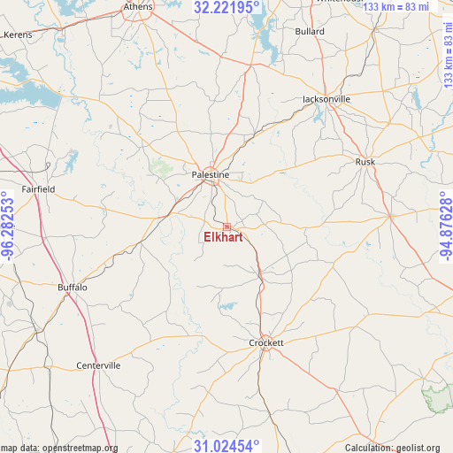
Elkhart GPS coordinates[2]
31° 37' 30.612" North, 95° 34' 45.84" West
| Map corner | latitude | longitude |
|---|---|---|
| Upper-left | 32.22195°, | -96.28253° |
| Center: | 31.62517°, | -95.5794° |
| Lower-right: | 31.02454°, | -94.87628° |
| Map W x H: | 133.1×133.1 km | = 82.7×82.7mi |
| max Lat: | 71.29058° ⇑89.4% North |
| Elkhart: | 31.62517° |
| min Lat: | ⇓10.6% South 19.06759° |
| min Long | Elkhart | max Long |
| -171.73463° | -95.5794° | -66.98998° |
| W 27.5%⇐ | ⇒72.5% E |
Elevation
Elevation of Elkhart is 122 m = 400 ft, and this is 172.8 m = 567 ft below average elevation for this country.
| Max E: |
3189 m = 10463 ft | 66.2% |
| Avg. | 294.8 m = 967 ft | |
| Elkhart | 122 m = 400 ft | |
Min E: |
-60 m = -197 ft | 33.8% |
See also: United States elevation on elevation.city.
Geographical zone
Elkhart is located in North temperate zone (between Tropic of Cancer and the Arctic Circle). Distance of this Northern Tropic circle is 910.5 km =565.8 mi to South.| Distance of | km | miles | from Elkhart |
|---|---|---|---|
| North Pole | 6490.7 | 4033.1 | to North |
| Arctic Circle | 3884.8 | 2413.9 | to North |
| Tropic Cancer | 910.5 | 565.8 | to South |
| Equator | 3516.4 | 2185 | to South |


Nearby cities:
15 places around Elkhart: (largest is in red/bold)
• Alto
48 km =29.8 mi,  86°
86°
• Berryville
52.5 km =32.6 mi,  11°
11°
• Buffalo
48.8 km =30.3 mi,  248°
248°
• Centerville
55.7 km =34.6 mi,  222°
222°
• Cooper
42.5 km =26.4 mi,  180°
180°
• Crockett
36.1 km =22.4 mi,  161°
161°
• Fairfield
56.5 km =35.1 mi,  281°
281°
• Frankston
48 km =29.8 mi, 8°
• Grapeland
17.6 km =10.9 mi,  147°
147°
• Hickory Creek
36.7 km =22.8 mi,  138°
138°
• Jacksonville
47.6 km =29.6 mi,  37°
37°
• Oakwood
25.9 km =16.1 mi,  260°
260°
• Palestine
16 km =9.9 mi,  342°
342°
• Rusk
44.8 km =27.8 mi,  64°
64°
• San Pedro
25.2 km =15.7 mi,  130°
130°
Sources, notices
• [Note1] Compared only with cities in United States existing in our database
• [Src1] Map data: © OpenStreetMap contributors (CC-BY-SA)
• [Src2] Other city data from geonames.org with taken over terms of usage.
• [Src3] Geographical zone / Annual Mean Temperature by Robert A. Rohde @ Wikipedia
