Palestine geodata
Palestine (Texas) is a seat of a second-order administrative division; located in United States in America/Chicago (GMT-5) time zone. With population of 18,288 people, there are 2741 cities with bigger population in this country. Compared to other cities in United States, 89.1% of cities are located further ↑North; 72.7% of cities are located further →East and 60.9% of cities have higher elevation than Palestine. Note1


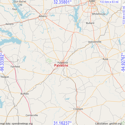
Palestine GPS coordinates[2]
31° 45' 43.632" North, 95° 37' 50.844" West
| Map corner | latitude | longitude |
|---|---|---|
| Upper-left | 32.35801°, | -96.33392° |
| Center: | 31.76212°, | -95.63079° |
| Lower-right: | 31.16237°, | -94.92767° |
| Map W x H: | 132.9×132.9 km | = 82.6×82.6mi |
| max Lat: | 71.29058° ⇑89.1% North |
| Palestine: | 31.76212° |
| min Lat: | ⇓10.9% South 19.06759° |
| min Long | Palestine | max Long |
| -171.73463° | -95.63079° | -66.98998° |
| W 27.3%⇐ | ⇒72.7% E |
Elevation
Elevation of Palestine is 150 m = 492 ft, and this is 144.8 m = 475 ft below average elevation for this country.
| Max E: |
3189 m = 10463 ft | 60.9% |
| Avg. | 294.8 m = 967 ft | |
| Palestine | 150 m = 492 ft | |
Min E: |
-60 m = -197 ft | 39.1% |
See also: United States elevation on elevation.city.
Geographical zone
Palestine is located in North temperate zone (between Tropic of Cancer and the Arctic Circle). Distance of this Northern Tropic circle is 925.7 km =575.2 mi to South.| Distance of | km | miles | from Palestine |
|---|---|---|---|
| North Pole | 6475.4 | 4023.6 | to North |
| Arctic Circle | 3869.6 | 2404.5 | to North |
| Tropic Cancer | 925.7 | 575.2 | to South |
| Equator | 3531.6 | 2194.4 | to South |


Nearby cities:
15 places around Palestine: (largest is in red/bold)
• Alto
54.2 km =33.7 mi,  103°
103°
• Athens
53.6 km =33.3 mi,  336°
336°
• Berryville
39.3 km =24.4 mi,  22°
22°
• Buffalo
52.3 km =32.5 mi,  230°
230°
• Bullard
51.2 km =31.8 mi,  34°
34°
• Crockett
52 km =32.3 mi,  161°
161°
• Elkhart
16 km =9.9 mi, 162°
• Fairfield
50.7 km =31.5 mi,  265°
265°
• Frankston
34.4 km =21.4 mi, 19°
• Grapeland
33.3 km =20.7 mi,  154°
154°
• Hickory Creek
51.7 km =32.1 mi, 145°
• Jacksonville
40.7 km =25.3 mi,  56°
56°
• Oakwood
28.6 km =17.8 mi, 226°
• Rusk
45.6 km =28.3 mi,  85°
85°
• San Pedro
39.8 km =24.7 mi,  143°
143°
Sources, notices
• [Note1] Compared only with cities in United States existing in our database
• [Src1] Map data: © OpenStreetMap contributors (CC-BY-SA)
• [Src2] Other city data from geonames.org with taken over terms of usage.
• [Src3] Geographical zone / Annual Mean Temperature by Robert A. Rohde @ Wikipedia
