Omaha geodata
Omaha (Texas) is a populated place; located in United States in America/Chicago (GMT-5) time zone. With population of 993 people, there are 16321 cities with bigger population in this country. Compared to other cities in United States, 84.4% of cities are located further ↑North; 70.5% of cities are located further →East and 65.2% of cities have higher elevation than Omaha. Note1


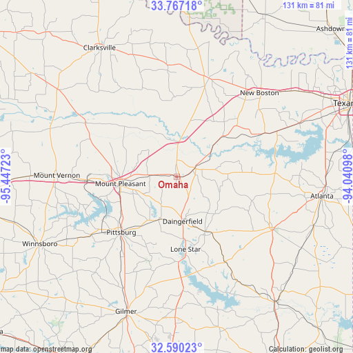
Omaha GPS coordinates[2]
33° 10' 50.448" North, 94° 44' 38.76" West
| Map corner | latitude | longitude |
|---|---|---|
| Upper-left | 33.76718°, | -95.44723° |
| Center: | 33.18068°, | -94.7441° |
| Lower-right: | 32.59023°, | -94.04098° |
| Map W x H: | 130.9×130.9 km | = 81.3×81.3mi |
| max Lat: | 71.29058° ⇑84.4% North |
| Omaha: | 33.18068° |
| min Lat: | ⇓15.6% South 19.06759° |
| min Long | Omaha | max Long |
| -171.73463° | -94.7441° | -66.98998° |
| W 29.5%⇐ | ⇒70.5% E |
Elevation
Elevation of Omaha is 127 m = 417 ft, and this is 167.8 m = 551 ft below average elevation for this country.
| Max E: |
3189 m = 10463 ft | 65.2% |
| Avg. | 294.8 m = 967 ft | |
| Omaha | 127 m = 417 ft | |
Min E: |
-60 m = -197 ft | 34.8% |
See also: United States elevation on elevation.city.
Geographical zone
Omaha is located in North temperate zone (between Tropic of Cancer and the Arctic Circle). Distance of this Northern Tropic circle is 1083.4 km =673.2 mi to South.| Distance of | km | miles | from Omaha |
|---|---|---|---|
| North Pole | 6317.7 | 3925.6 | to North |
| Arctic Circle | 3711.8 | 2306.4 | to North |
| Tropic Cancer | 1083.4 | 673.2 | to South |
| Equator | 3689.3 | 2292.4 | to South |


Nearby cities:
15 places around Omaha: (largest is in red/bold)
• Daingerfield
16.7 km =10.4 mi,  172°
172°
• De Kalb
38.4 km =23.9 mi,  18°
18°
• Hughes Springs
22.8 km =14.2 mi,  152°
152°
• Linden
39.9 km =24.8 mi,  117°
117°
• Lone Star
26.5 km =16.5 mi, 172°
• Maud
41 km =25.5 mi,  65°
65°
• Mount Pleasant
21 km =13 mi,  262°
262°
• Mount Vernon
44.4 km =27.6 mi,  271°
271°
• Naples
6.4 km =4 mi, 67°
• New Boston
43.5 km =27 mi,  44°
44°
• Ore City
42.4 km =26.3 mi,  177°
177°
• Pittsburg
29.2 km =18.1 mi,  225°
225°
• Redwater
49.6 km =30.8 mi, 66°
• Talco
39.1 km =24.3 mi,  301°
301°
• Winfield
34.3 km =21.3 mi, 267°
Sources, notices
• [Note1] Compared only with cities in United States existing in our database
• [Src1] Map data: © OpenStreetMap contributors (CC-BY-SA)
• [Src2] Other city data from geonames.org with taken over terms of usage.
• [Src3] Geographical zone / Annual Mean Temperature by Robert A. Rohde @ Wikipedia
