Pittsburg geodata
Pittsburg (Texas) is a seat of a second-order administrative division; located in United States in America/Chicago (GMT-5) time zone. With population of 4,602 people, there are 7539 cities with bigger population in this country. Compared to other cities in United States, 85.2% of cities are located further ↑North; 71% of cities are located further →East and 66.2% of cities have higher elevation than Pittsburg. Note1


Pittsburg GPS coordinates[2]
32° 59' 43.44" North, 94° 57' 56.772" West
| Map corner | latitude | longitude |
|---|---|---|
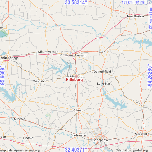
| Upper-left | 33.58314°, | -95.6689° |
| Center: | 32.9954°, | -94.96577° |
| Lower-right: | 32.40371°, | -94.26265° |
| Map W x H: | 131.1×131.1 km | = 81.5×81.5mi |
| max Lat: | 71.29058° ⇑85.2% North |
| Pittsburg: | 32.9954° |
| min Lat: | ⇓14.8% South 19.06759° |
| min Long | Pittsburg | max Long |
| -171.73463° | -94.96577° | -66.98998° |
| W 29%⇐ | ⇒71% E |
Elevation
Elevation of Pittsburg is 122 m = 400 ft, and this is 172.8 m = 567 ft below average elevation for this country.
| Max E: |
3189 m = 10463 ft | 66.2% |
| Avg. | 294.8 m = 967 ft | |
| Pittsburg | 122 m = 400 ft | |
Min E: |
-60 m = -197 ft | 33.8% |
See also: United States elevation on elevation.city.
Geographical zone
Pittsburg is located in North temperate zone (between Tropic of Cancer and the Arctic Circle). Distance of this Northern Tropic circle is 1062.8 km =660.4 mi to South.| Distance of | km | miles | from Pittsburg |
|---|---|---|---|
| North Pole | 6338.3 | 3938.4 | to North |
| Arctic Circle | 3732.4 | 2319.2 | to North |
| Tropic Cancer | 1062.8 | 660.4 | to South |
| Equator | 3668.7 | 2279.6 | to South |


Nearby cities:
15 places around Pittsburg: (largest is in red/bold)
• Daingerfield
23.1 km =14.4 mi,  79°
79°
• East Mountain
45.8 km =28.5 mi,  167°
167°
• Gilmer
29.7 km =18.5 mi,  175°
175°
• Holly Lake Ranch
38.1 km =23.7 mi,  214°
214°
• Hughes Springs
31.2 km =19.4 mi,  89°
89°
• Lone Star
24.8 km =15.4 mi,  103°
103°
• Mount Pleasant
17.9 km =11.1 mi,  359°
359°
• Mount Vernon
32.1 km =19.9 mi,  312°
312°
• Naples
35.2 km =21.9 mi,  49°
49°
• Omaha
29.2 km =18.1 mi, 45°
• Ore City
31.5 km =19.6 mi,  133°
133°
• Pine Forest
41.2 km =25.6 mi,  288°
288°
• Talco
42.8 km =26.6 mi,  342°
342°
• Winfield
23.5 km =14.6 mi,  324°
324°
• Winnsboro
30.6 km =19 mi,  262°
262°
Sources, notices
• [Note1] Compared only with cities in United States existing in our database
• [Src1] Map data: © OpenStreetMap contributors (CC-BY-SA)
• [Src2] Other city data from geonames.org with taken over terms of usage.
• [Src3] Geographical zone / Annual Mean Temperature by Robert A. Rohde @ Wikipedia
