Hughes Springs geodata
Hughes Springs (Texas) is a populated place; located in United States in America/Chicago (GMT-5) time zone. With population of 1,776 people, there are 12642 cities with bigger population in this country. Compared to other cities in United States, 85.1% of cities are located further ↑North; 70.2% of cities are located further →East and 66.9% of cities have higher elevation than Hughes Springs. Note1


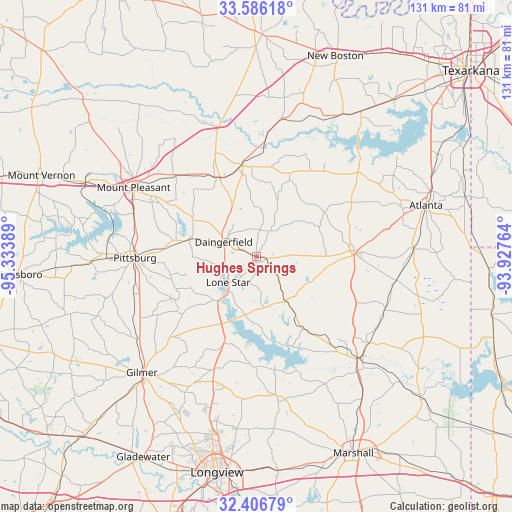
Hughes Springs GPS coordinates[2]
32° 59' 54.456" North, 94° 37' 50.736" West
| Map corner | latitude | longitude |
|---|---|---|
| Upper-left | 33.58618°, | -95.33389° |
| Center: | 32.99846°, | -94.63076° |
| Lower-right: | 32.40679°, | -93.92764° |
| Map W x H: | 131.1×131.1 km | = 81.5×81.5mi |
| max Lat: | 71.29058° ⇑85.1% North |
| Hughes Springs: | 32.99846° |
| min Lat: | ⇓14.9% South 19.06759° |
| min Long | Hughes Springs | max Long |
| -171.73463° | -94.63076° | -66.98998° |
| W 29.8%⇐ | ⇒70.2% E |
Elevation
Elevation of Hughes Springs is 118 m = 387 ft, and this is 176.8 m = 580 ft below average elevation for this country.
| Max E: |
3189 m = 10463 ft | 66.9% |
| Avg. | 294.8 m = 967 ft | |
| Hughes Springs | 118 m = 387 ft | |
Min E: |
-60 m = -197 ft | 33.1% |
See also: United States elevation on elevation.city.
Geographical zone
Hughes Springs is located in North temperate zone (between Tropic of Cancer and the Arctic Circle). Distance of this Northern Tropic circle is 1063.2 km =660.6 mi to South.| Distance of | km | miles | from Hughes Springs |
|---|---|---|---|
| North Pole | 6338 | 3938.2 | to North |
| Arctic Circle | 3732.1 | 2319 | to North |
| Tropic Cancer | 1063.2 | 660.6 | to South |
| Equator | 3669.1 | 2279.9 | to South |


Nearby cities:
15 places around Hughes Springs: (largest is in red/bold)
• Atlanta
45.3 km =28.1 mi,  73°
73°
• Daingerfield
9.3 km =5.8 mi,  293°
293°
• East Mountain
49.7 km =30.9 mi,  205°
205°
• Gilmer
41.8 km =26 mi,  224°
224°
• Jefferson
37.8 km =23.5 mi,  135°
135°
• Linden
24.8 km =15.4 mi,  86°
86°
• Lone Star
9.3 km =5.8 mi,  229°
229°
• Maud
45.8 km =28.5 mi,  35°
35°
• Mount Pleasant
36 km =22.4 mi,  299°
299°
• Naples
23.2 km =14.4 mi,  348°
348°
• Omaha
22.8 km =14.2 mi,  332°
332°
• Ore City
23.6 km =14.7 mi,  200°
200°
• Pittsburg
31.2 km =19.4 mi,  269°
269°
• Queen City
47.8 km =29.7 mi, 69°
• Winfield
48.6 km =30.2 mi, 292°
Sources, notices
• [Note1] Compared only with cities in United States existing in our database
• [Src1] Map data: © OpenStreetMap contributors (CC-BY-SA)
• [Src2] Other city data from geonames.org with taken over terms of usage.
• [Src3] Geographical zone / Annual Mean Temperature by Robert A. Rohde @ Wikipedia
