Silsbee geodata
Silsbee (Texas) is a populated place; located in United States in America/Chicago (GMT-5) time zone. With population of 6,688 people, there are 5983 cities with bigger population in this country. Compared to other cities in United States, 92.4% of cities are located further ↑North; 69% of cities are located further →East and 85.4% of cities have higher elevation than Silsbee. Note1


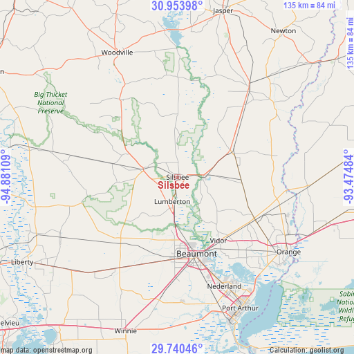
Silsbee GPS coordinates[2]
30° 20' 56.76" North, 94° 10' 40.656" West
| Map corner | latitude | longitude |
|---|---|---|
| Upper-left | 30.95398°, | -94.88109° |
| Center: | 30.3491°, | -94.17796° |
| Lower-right: | 29.74046°, | -93.47484° |
| Map W x H: | 134.9×134.9 km | = 83.8×83.8mi |
| max Lat: | 71.29058° ⇑92.4% North |
| Silsbee: | 30.3491° |
| min Lat: | ⇓7.6% South 19.06759° |
| min Long | Silsbee | max Long |
| -171.73463° | -94.17796° | -66.98998° |
| W 31%⇐ | ⇒69% E |
Elevation
Elevation of Silsbee is 27 m = 89 ft, and this is 267.8 m = 879 ft below average elevation for this country.
| Max E: |
3189 m = 10463 ft | 85.4% |
| Avg. | 294.8 m = 967 ft | |
| Silsbee | 27 m = 89 ft | |
Min E: |
-60 m = -197 ft | 14.6% |
See also: United States elevation on elevation.city.
Geographical zone
Silsbee is located in North temperate zone (between Tropic of Cancer and the Arctic Circle). Distance of this Northern Tropic circle is 768.6 km =477.6 mi to South.| Distance of | km | miles | from Silsbee |
|---|---|---|---|
| North Pole | 6632.6 | 4121.3 | to North |
| Arctic Circle | 4026.7 | 2502.1 | to North |
| Tropic Cancer | 768.6 | 477.6 | to South |
| Equator | 3374.5 | 2096.8 | to South |


Nearby cities:
15 places around Silsbee: (largest is in red/bold)
• Beaumont
30.1 km =18.7 mi,  165°
165°
• Bevil Oaks
23.8 km =14.8 mi,  201°
201°
• Buna
22.7 km =14.1 mi,  65°
65°
• China
36.8 km =22.9 mi, 204°
• Evadale
10.1 km =6.3 mi,  86°
86°
• Kountze
13.1 km =8.1 mi,  280°
280°
• Lumberton
9.5 km =5.9 mi,  192°
192°
• Mauriceville
34 km =21.1 mi,  118°
118°
• Pine Forest
23.2 km =14.4 mi,  143°
143°
• Pinewood Estates
24.7 km =15.3 mi,  213°
213°
• Rose City
30 km =18.6 mi,  156°
156°
• Sour Lake
32.3 km =20.1 mi,  223°
223°
• Vidor
28.8 km =17.9 mi,  147°
147°
• Warren
36.9 km =22.9 mi,  323°
323°
• Wildwood
31.9 km =19.8 mi,  307°
307°
Sources, notices
• [Note1] Compared only with cities in United States existing in our database
• [Src1] Map data: © OpenStreetMap contributors (CC-BY-SA)
• [Src2] Other city data from geonames.org with taken over terms of usage.
• [Src3] Geographical zone / Annual Mean Temperature by Robert A. Rohde @ Wikipedia
