Rollingwood geodata
Rollingwood (Texas) is a populated place; located in United States in America/Chicago (GMT-5) time zone. With population of 1,543 people, there are 13497 cities with bigger population in this country. Compared to other cities in United States, 92.6% of cities are located further ↑North; 78% of cities are located further →East and 51.2% of cities have lower elevation than Rollingwood. Note1


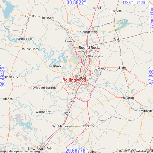
Rollingwood GPS coordinates[2]
30° 16' 36.732" North, 97° 47' 28.032" West
| Map corner | latitude | longitude |
|---|---|---|
| Upper-left | 30.8822°, | -98.49425° |
| Center: | 30.27687°, | -97.79112° |
| Lower-right: | 29.66778°, | -97.088° |
| Map W x H: | 135×135 km | = 83.9×83.9mi |
| max Lat: | 71.29058° ⇑92.6% North |
| Rollingwood: | 30.27687° |
| min Lat: | ⇓7.4% South 19.06759° |
| min Long | Rollingwood | max Long |
| -171.73463° | -97.79112° | -66.98998° |
| W 22%⇐ | ⇒78% E |
Elevation
Elevation of Rollingwood is 203 m = 666 ft, and this is 91.8 m = 301 ft below average elevation for this country.
| Max E: |
3189 m = 10463 ft | 48.8% |
| Avg. | 294.8 m = 967 ft | |
| Rollingwood | 203 m = 666 ft | |
Min E: |
-60 m = -197 ft | 51.2% |
See also: United States elevation on elevation.city.
Geographical zone
Rollingwood is located in North temperate zone (between Tropic of Cancer and the Arctic Circle). Distance of this Northern Tropic circle is 760.6 km =472.6 mi to South.| Distance of | km | miles | from Rollingwood |
|---|---|---|---|
| North Pole | 6640.6 | 4126.3 | to North |
| Arctic Circle | 4034.7 | 2507 | to North |
| Tropic Cancer | 760.6 | 472.6 | to South |
| Equator | 3366.5 | 2091.8 | to South |


Nearby cities:
15 places around Rollingwood: (largest is in red/bold)
• Anderson Mill
19.8 km =12.3 mi,  355°
355°
• Austin
4.7 km =2.9 mi,  103°
103°
• Barton Creek
7.6 km =4.7 mi,  277°
277°
• Bee Cave
15.2 km =9.4 mi, 283°
• Hornsby Bend
20.2 km =12.6 mi, 99°
• Jollyville
18.5 km =11.5 mi,  4°
4°
• Lakeway
20.5 km =12.7 mi,  298°
298°
• Lost Creek
5.5 km =3.4 mi,  292°
292°
• Manchaca
15.7 km =9.8 mi,  194°
194°
• Onion Creek
15.6 km =9.7 mi,  177°
177°
• San Leanna
14.8 km =9.2 mi, 190°
• Shady Hollow
14.2 km =8.8 mi,  208°
208°
• Sunset Valley
5.8 km =3.6 mi, 191°
• The Hills
20.2 km =12.6 mi, 293°
• West Lake Hills
2.6 km =1.6 mi,  336°
336°
Sources, notices
• [Note1] Compared only with cities in United States existing in our database
• [Src1] Map data: © OpenStreetMap contributors (CC-BY-SA)
• [Src2] Other city data from geonames.org with taken over terms of usage.
• [Src3] Geographical zone / Annual Mean Temperature by Robert A. Rohde @ Wikipedia
