Hornsby Bend geodata
Hornsby Bend (Texas) is a populated place; located in United States in America/Chicago (GMT-5) time zone. With population of 6,791 people, there are 5926 cities with bigger population in this country. Compared to other cities in United States, 92.6% of cities are located further ↑North; 77.4% of cities are located further →East and 62.9% of cities have higher elevation than Hornsby Bend. Note1


Hornsby Bend GPS coordinates[2]
30° 14' 50.748" North, 97° 34' 59.988" West
| Map corner | latitude | longitude |
|---|---|---|
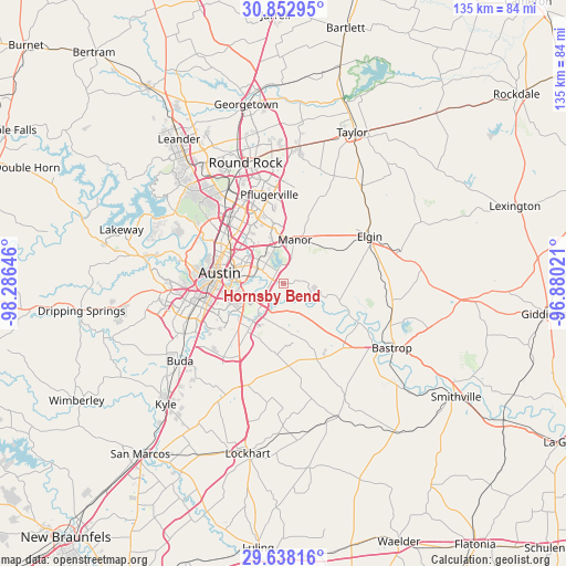
| Upper-left | 30.85295°, | -98.28646° |
| Center: | 30.24743°, | -97.58333° |
| Lower-right: | 29.63816°, | -96.88021° |
| Map W x H: | 135.1×135.1 km | = 83.9×83.9mi |
| max Lat: | 71.29058° ⇑92.6% North |
| Hornsby Bend: | 30.24743° |
| min Lat: | ⇓7.4% South 19.06759° |
| min Long | Hornsby Bend | max Long |
| -171.73463° | -97.58333° | -66.98998° |
| W 22.6%⇐ | ⇒77.4% E |
Elevation
Elevation of Hornsby Bend is 139 m = 456 ft, and this is 155.8 m = 511 ft below average elevation for this country.
| Max E: |
3189 m = 10463 ft | 62.9% |
| Avg. | 294.8 m = 967 ft | |
| Hornsby Bend | 139 m = 456 ft | |
Min E: |
-60 m = -197 ft | 37.1% |
See also: United States elevation on elevation.city.
Geographical zone
Hornsby Bend is located in North temperate zone (between Tropic of Cancer and the Arctic Circle). Distance of this Northern Tropic circle is 757.3 km =470.6 mi to South.| Distance of | km | miles | from Hornsby Bend |
|---|---|---|---|
| North Pole | 6643.9 | 4128.3 | to North |
| Arctic Circle | 4038 | 2509.1 | to North |
| Tropic Cancer | 757.3 | 470.6 | to South |
| Equator | 3363.2 | 2089.8 | to South |


Nearby cities:
15 places around Hornsby Bend: (largest is in red/bold)
• Austin
15.5 km =9.6 mi,  278°
278°
• Elgin
23.4 km =14.5 mi,  60°
60°
• Garfield
7.1 km =4.4 mi,  159°
159°
• Lost Creek
25.6 km =15.9 mi, 282°
• Manor
10.7 km =6.6 mi,  13°
13°
• Mustang Ridge
23.6 km =14.7 mi,  206°
206°
• Onion Creek
22.9 km =14.2 mi,  237°
237°
• Pflugerville
21.6 km =13.4 mi,  350°
350°
• Rollingwood
20.2 km =12.6 mi, 279°
• San Leanna
25.2 km =15.7 mi, 243°
• Sunset Valley
21.3 km =13.2 mi,  263°
263°
• Wells Branch
23.9 km =14.9 mi,  337°
337°
• West Lake Hills
21.7 km =13.5 mi, 284°
• Windemere
24.4 km =15.2 mi, 344°
• Wyldwood
16.9 km =10.5 mi,  141°
141°
Sources, notices
• [Note1] Compared only with cities in United States existing in our database
• [Src1] Map data: © OpenStreetMap contributors (CC-BY-SA)
• [Src2] Other city data from geonames.org with taken over terms of usage.
• [Src3] Geographical zone / Annual Mean Temperature by Robert A. Rohde @ Wikipedia
