San Leanna geodata
San Leanna (Texas) is a populated place; located in United States in America/Chicago (GMT-5) time zone. With population of 536 people, there are 20440 cities with bigger population in this country. Compared to other cities in United States, 93% of cities are located further ↑North; 78.1% of cities are located further →East and 53.9% of cities have lower elevation than San Leanna. Note1


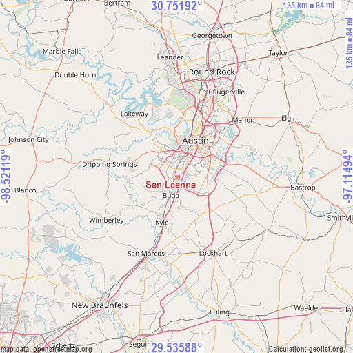
San Leanna GPS coordinates[2]
30° 8' 44.772" North, 97° 49' 5.016" West
| Map corner | latitude | longitude |
|---|---|---|
| Upper-left | 30.75192°, | -98.52119° |
| Center: | 30.14577°, | -97.81806° |
| Lower-right: | 29.53588°, | -97.11494° |
| Map W x H: | 135.2×135.2 km | = 84×84mi |
| max Lat: | 71.29058° ⇑93% North |
| San Leanna: | 30.14577° |
| min Lat: | ⇓7% South 19.06759° |
| min Long | San Leanna | max Long |
| -171.73463° | -97.81806° | -66.98998° |
| W 21.9%⇐ | ⇒78.1% E |
Elevation
Elevation of San Leanna is 214 m = 702 ft, and this is 80.8 m = 265 ft below average elevation for this country.
| Max E: |
3189 m = 10463 ft | 46.1% |
| Avg. | 294.8 m = 967 ft | |
| San Leanna | 214 m = 702 ft | |
Min E: |
-60 m = -197 ft | 53.9% |
See also: United States elevation on elevation.city.
Geographical zone
San Leanna is located in North temperate zone (between Tropic of Cancer and the Arctic Circle). Distance of this Northern Tropic circle is 746 km =463.5 mi to South.| Distance of | km | miles | from San Leanna |
|---|---|---|---|
| North Pole | 6655.2 | 4135.3 | to North |
| Arctic Circle | 4049.3 | 2516.1 | to North |
| Tropic Cancer | 746 | 463.5 | to South |
| Equator | 3351.9 | 2082.8 | to South |


Nearby cities:
15 places around San Leanna: (largest is in red/bold)
• Austin
15.3 km =9.5 mi,  28°
28°
• Barton Creek
16.3 km =10.1 mi,  342°
342°
• Buda
7.1 km =4.4 mi,  197°
197°
• Kyle
18.3 km =11.4 mi, 198°
• Lost Creek
16.8 km =10.4 mi,  351°
351°
• Manchaca
1.5 km =0.9 mi,  248°
248°
• Mountain City
13.8 km =8.6 mi,  208°
208°
• Mustang Ridge
15.7 km =9.8 mi,  128°
128°
• Niederwald
17.5 km =10.9 mi,  150°
150°
• Onion Creek
3.4 km =2.1 mi,  107°
107°
• Rollingwood
14.8 km =9.2 mi,  10°
10°
• Shady Hollow
4.8 km =3 mi,  296°
296°
• Sunset Valley
9 km =5.6 mi, 8°
• Uhland
21.1 km =13.1 mi,  171°
171°
• West Lake Hills
17 km =10.6 mi, 5°
Sources, notices
• [Note1] Compared only with cities in United States existing in our database
• [Src1] Map data: © OpenStreetMap contributors (CC-BY-SA)
• [Src2] Other city data from geonames.org with taken over terms of usage.
• [Src3] Geographical zone / Annual Mean Temperature by Robert A. Rohde @ Wikipedia
