Austin geodata
Austin (Texas) is a seat of a first-order administrative division; located in United States in America/Chicago (GMT-5) time zone. With population of 931,830 people, there are 14 cities with bigger population in this country. Compared to other cities in United States, 92.6% of cities are located further ↑North; 77.8% of cities are located further →East and 58% of cities have higher elevation than Austin. Note1


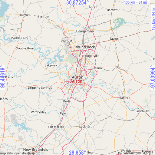
Austin GPS coordinates[2]
30° 16' 1.74" North, 97° 44' 35.016" West
| Map corner | latitude | longitude |
|---|---|---|
| Upper-left | 30.87254°, | -98.44619° |
| Center: | 30.26715°, | -97.74306° |
| Lower-right: | 29.658°, | -97.03994° |
| Map W x H: | 135×135 km | = 83.9×83.9mi |
| max Lat: | 71.29058° ⇑92.6% North |
| Austin: | 30.26715° |
| min Lat: | ⇓7.4% South 19.06759° |
| min Long | Austin | max Long |
| -171.73463° | -97.74306° | -66.98998° |
| W 22.2%⇐ | ⇒77.8% E |
Elevation
Elevation of Austin is 165 m = 541 ft, and this is 129.8 m = 426 ft below average elevation for this country.
| Max E: |
3189 m = 10463 ft | 58% |
| Avg. | 294.8 m = 967 ft | |
| Austin | 165 m = 541 ft | |
Min E: |
-60 m = -197 ft | 42% |
See also: Austin elevation on elevation.city.
Geographical zone
Austin is located in North temperate zone (between Tropic of Cancer and the Arctic Circle). Distance of this Northern Tropic circle is 759.5 km =471.9 mi to South.| Distance of | km | miles | from Austin |
|---|---|---|---|
| North Pole | 6641.7 | 4127 | to North |
| Arctic Circle | 4035.8 | 2507.7 | to North |
| Tropic Cancer | 759.5 | 471.9 | to South |
| Equator | 3365.4 | 2091.2 | to South |


Nearby cities:
15 places around Austin: (largest is in red/bold)
• Barton Creek
12.3 km =7.6 mi,  279°
279°
• Bee Cave
19.9 km =12.4 mi, 283°
• Garfield
19.9 km =12.4 mi,  116°
116°
• Hornsby Bend
15.5 km =9.6 mi,  98°
98°
• Jollyville
19.8 km =12.3 mi,  351°
351°
• Lost Creek
10.2 km =6.3 mi,  287°
287°
• Manchaca
16.5 km =10.3 mi,  211°
211°
• Manor
19.7 km =12.2 mi,  65°
65°
• Onion Creek
15 km =9.3 mi,  195°
195°
• Rollingwood
4.7 km =2.9 mi, 283°
• San Leanna
15.3 km =9.5 mi, 208°
• Shady Hollow
16.1 km =10 mi,  225°
225°
• Sunset Valley
7.4 km =4.6 mi, 231°
• Wells Branch
20.8 km =12.9 mi,  17°
17°
• West Lake Hills
6.6 km =4.1 mi,  301°
301°
Sources, notices
• [Note1] Compared only with cities in United States existing in our database
• [Src1] Map data: © OpenStreetMap contributors (CC-BY-SA)
• [Src2] Other city data from geonames.org with taken over terms of usage.
• [Src3] Geographical zone / Annual Mean Temperature by Robert A. Rohde @ Wikipedia
