Uhland geodata
Uhland (Texas) is a populated place; located in United States in America/Chicago (GMT-5) time zone. With population of 1,052 people, there are 15940 cities with bigger population in this country. Compared to other cities in United States, 93.5% of cities are located further ↑North; 78% of cities are located further →East and 57.5% of cities have higher elevation than Uhland. Note1


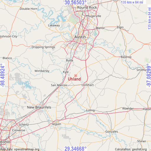
Uhland GPS coordinates[2]
29° 57' 27.792" North, 97° 47' 9.996" West
| Map corner | latitude | longitude |
|---|---|---|
| Upper-left | 30.56503°, | -98.48924° |
| Center: | 29.95772°, | -97.78611° |
| Lower-right: | 29.34668°, | -97.08299° |
| Map W x H: | 135.5×135.5 km | = 84.2×84.2mi |
| max Lat: | 71.29058° ⇑93.5% North |
| Uhland: | 29.95772° |
| min Lat: | ⇓6.5% South 19.06759° |
| min Long | Uhland | max Long |
| -171.73463° | -97.78611° | -66.98998° |
| W 22%⇐ | ⇒78% E |
Elevation
Elevation of Uhland is 168 m = 551 ft, and this is 126.8 m = 416 ft below average elevation for this country.
| Max E: |
3189 m = 10463 ft | 57.5% |
| Avg. | 294.8 m = 967 ft | |
| Uhland | 168 m = 551 ft | |
Min E: |
-60 m = -197 ft | 42.5% |
See also: United States elevation on elevation.city.
Geographical zone
Uhland is located in North temperate zone (between Tropic of Cancer and the Arctic Circle). Distance of this Northern Tropic circle is 725.1 km =450.6 mi to South.| Distance of | km | miles | from Uhland |
|---|---|---|---|
| North Pole | 6676.1 | 4148.3 | to North |
| Arctic Circle | 4070.2 | 2529.1 | to North |
| Tropic Cancer | 725.1 | 450.6 | to South |
| Equator | 3331 | 2069.8 | to South |


Nearby cities:
15 places around Uhland: (largest is in red/bold)
• Buda
15.1 km =9.4 mi,  339°
339°
• Kyle
9.4 km =5.8 mi,  291°
291°
• Lockhart
13.8 km =8.6 mi,  125°
125°
• Manchaca
20.8 km =12.9 mi,  347°
347°
• Martindale
13.5 km =8.4 mi,  202°
202°
• Mountain City
13.1 km =8.1 mi,  312°
312°
• Mustang Ridge
14.3 km =8.9 mi,  39°
39°
• Niederwald
8 km =5 mi, 44°
• Onion Creek
19.9 km =12.4 mi,  0°
0°
• Redwood
20.4 km =12.7 mi,  216°
216°
• San Leanna
21.1 km =13.1 mi, 351°
• San Marcos
17.1 km =10.6 mi,  241°
241°
• Shady Hollow
24.2 km =15 mi, 342°
• Sunset Valley
29.9 km =18.6 mi,  356°
356°
• Wimberley
30.4 km =18.9 mi,  278°
278°
Sources, notices
• [Note1] Compared only with cities in United States existing in our database
• [Src1] Map data: © OpenStreetMap contributors (CC-BY-SA)
• [Src2] Other city data from geonames.org with taken over terms of usage.
• [Src3] Geographical zone / Annual Mean Temperature by Robert A. Rohde @ Wikipedia
