Seymour geodata
Seymour (Texas) is a seat of a second-order administrative division; located in United States in America/Chicago (GMT-5) time zone. With population of 2,652 people, there are 10280 cities with bigger population in this country. Compared to other cities in United States, 82.7% of cities are located further ↑North; 80.1% of cities are located further →East and 83.7% of cities have lower elevation than Seymour. Note1


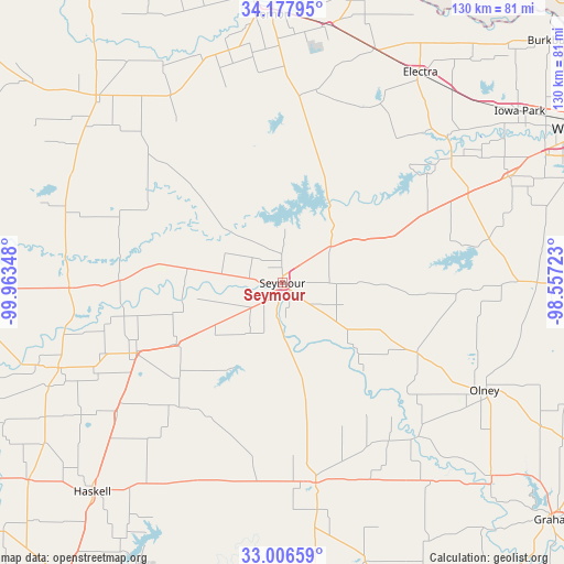
Seymour GPS coordinates[2]
33° 35' 39.336" North, 99° 15' 37.26" West
| Map corner | latitude | longitude |
|---|---|---|
| Upper-left | 34.17795°, | -99.96348° |
| Center: | 33.59426°, | -99.26035° |
| Lower-right: | 33.00659°, | -98.55723° |
| Map W x H: | 130.2×130.2 km | = 80.9×80.9mi |
| max Lat: | 71.29058° ⇑82.7% North |
| Seymour: | 33.59426° |
| min Lat: | ⇓17.3% South 19.06759° |
| min Long | Seymour | max Long |
| -171.73463° | -99.26035° | -66.98998° |
| W 19.9%⇐ | ⇒80.1% E |
Elevation
Elevation of Seymour is 399 m = 1309 ft, and this is 104.2 m = 342 ft above average elevation for this country.
| Max E: |
3189 m = 10463 ft | 16.3% |
| Seymour | 399 m 1309 ft | |
| Avg. | 294.8 m = 967 ft | |
Min E: |
-60 m = -197 ft | 83.7% |
See also: United States elevation on elevation.city.
Geographical zone
Seymour is located in North temperate zone (between Tropic of Cancer and the Arctic Circle). Distance of this Northern Tropic circle is 1129.4 km =701.8 mi to South.| Distance of | km | miles | from Seymour |
|---|---|---|---|
| North Pole | 6271.7 | 3897.1 | to North |
| Arctic Circle | 3665.8 | 2277.8 | to North |
| Tropic Cancer | 1129.4 | 701.8 | to South |
| Equator | 3735.3 | 2321 | to South |


Nearby cities:
15 places around Seymour: (largest is in red/bold)
• Archer City
58.8 km =36.5 mi,  89°
89°
• Benjamin
49.3 km =30.6 mi,  268°
268°
• Crowell
61 km =37.9 mi,  315°
315°
• Electra
57.7 km =35.9 mi,  33°
33°
• Haskell
65.5 km =40.7 mi,  222°
222°
• Holliday
57.8 km =35.9 mi,  64°
64°
• Iowa Park
67.6 km =42 mi,  54°
54°
• Knox City
55.4 km =34.4 mi,  249°
249°
• Lakeside City
71.1 km =44.2 mi,  68°
68°
• Munday
37.3 km =23.2 mi,  244°
244°
• Newcastle
65.8 km =40.9 mi,  132°
132°
• Olney
53.2 km =33.1 mi,  117°
117°
• Rule
74.4 km =46.2 mi,  232°
232°
• Throckmorton
46.8 km =29.1 mi,  170°
170°
• Vernon
62.4 km =38.8 mi,  359°
359°
Sources, notices
• [Note1] Compared only with cities in United States existing in our database
• [Src1] Map data: © OpenStreetMap contributors (CC-BY-SA)
• [Src2] Other city data from geonames.org with taken over terms of usage.
• [Src3] Geographical zone / Annual Mean Temperature by Robert A. Rohde @ Wikipedia
