Holliday geodata
Holliday (Texas) is a populated place; located in United States in America/Chicago (GMT-5) time zone. With population of 1,706 people, there are 12888 cities with bigger population in this country. Compared to other cities in United States, 81.5% of cities are located further ↑North; 79.6% of cities are located further →East and 76.6% of cities have lower elevation than Holliday. Note1


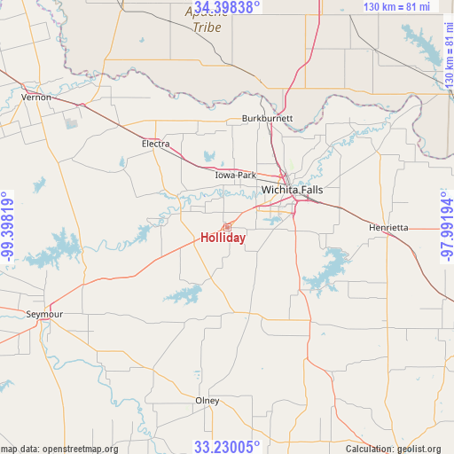
Holliday GPS coordinates[2]
33° 48' 58.356" North, 98° 41' 42.216" West
| Map corner | latitude | longitude |
|---|---|---|
| Upper-left | 34.39838°, | -99.39819° |
| Center: | 33.81621°, | -98.69506° |
| Lower-right: | 33.23005°, | -97.99194° |
| Map W x H: | 129.9×129.9 km | = 80.7×80.7mi |
| max Lat: | 71.29058° ⇑81.5% North |
| Holliday: | 33.81621° |
| min Lat: | ⇓18.5% South 19.06759° |
| min Long | Holliday | max Long |
| -171.73463° | -98.69506° | -66.98998° |
| W 20.4%⇐ | ⇒79.6% E |
Elevation
Elevation of Holliday is 325 m = 1066 ft, and this is 30.2 m = 99 ft above average elevation for this country.
| Max E: |
3189 m = 10463 ft | 23.4% |
| Holliday | 325 m 1066 ft | |
| Avg. | 294.8 m = 967 ft | |
Min E: |
-60 m = -197 ft | 76.6% |
See also: United States elevation on elevation.city.
Geographical zone
Holliday is located in North temperate zone (between Tropic of Cancer and the Arctic Circle). Distance of this Northern Tropic circle is 1154.1 km =717.1 mi to South.| Distance of | km | miles | from Holliday |
|---|---|---|---|
| North Pole | 6247.1 | 3881.8 | to North |
| Arctic Circle | 3641.2 | 2262.5 | to North |
| Tropic Cancer | 1154.1 | 717.1 | to South |
| Equator | 3760 | 2336.4 | to South |


Nearby cities:
15 places around Holliday: (largest is in red/bold)
• Archer City
25.4 km =15.8 mi,  165°
165°
• Burkburnett
33.4 km =20.8 mi,  20°
20°
• Electra
31.4 km =19.5 mi,  318°
318°
• Grandfield
45.8 km =28.5 mi,  1°
1°
• Henrietta
46.2 km =28.7 mi,  89°
89°
• Iowa Park
15.2 km =9.4 mi,  9°
9°
• Lakeside City
13.9 km =8.6 mi,  84°
84°
• Newcastle
69.3 km =43.1 mi,  183°
183°
• Olney
49.8 km =30.9 mi,  186°
186°
• Petrolia
48 km =29.8 mi,  62°
62°
• Seymour
57.8 km =35.9 mi,  244°
244°
• Temple
66 km =41 mi,  39°
39°
• Vernon
64.8 km =40.3 mi,  305°
305°
• Walters
70.2 km =43.6 mi,  30°
30°
• Wichita Falls
21.5 km =13.4 mi, 59°
Sources, notices
• [Note1] Compared only with cities in United States existing in our database
• [Src1] Map data: © OpenStreetMap contributors (CC-BY-SA)
• [Src2] Other city data from geonames.org with taken over terms of usage.
• [Src3] Geographical zone / Annual Mean Temperature by Robert A. Rohde @ Wikipedia
