Vernon geodata
Vernon (Texas) is a seat of a second-order administrative division; located in United States in America/Chicago (GMT-5) time zone. With population of 10,573 people, there are 4303 cities with bigger population in this country. Compared to other cities in United States, 79.2% of cities are located further ↑North; 80.1% of cities are located further →East and 80.7% of cities have lower elevation than Vernon. Note1


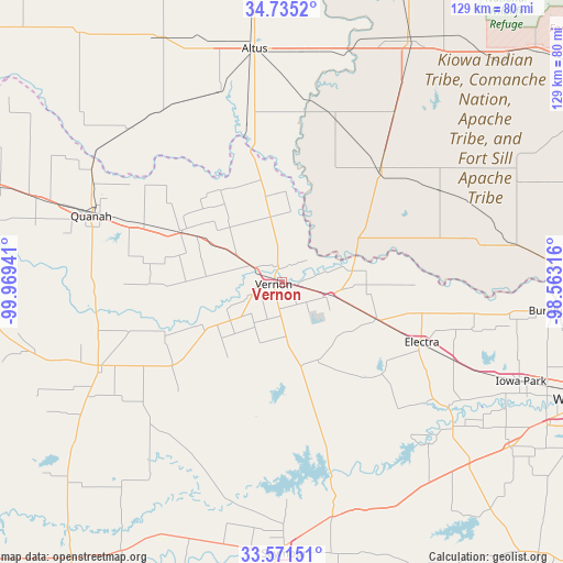
Vernon GPS coordinates[2]
34° 9' 19.296" North, 99° 15' 58.608" West
| Map corner | latitude | longitude |
|---|---|---|
| Upper-left | 34.7352°, | -99.96941° |
| Center: | 34.15536°, | -99.26628° |
| Lower-right: | 33.57151°, | -98.56316° |
| Map W x H: | 129.4×129.4 km | = 80.4×80.4mi |
| max Lat: | 71.29058° ⇑79.2% North |
| Vernon: | 34.15536° |
| min Lat: | ⇓20.8% South 19.06759° |
| min Long | Vernon | max Long |
| -171.73463° | -99.26628° | -66.98998° |
| W 19.9%⇐ | ⇒80.1% E |
Elevation
Elevation of Vernon is 361 m = 1184 ft, and this is 66.2 m = 217 ft above average elevation for this country.
| Max E: |
3189 m = 10463 ft | 19.3% |
| Vernon | 361 m 1184 ft | |
| Avg. | 294.8 m = 967 ft | |
Min E: |
-60 m = -197 ft | 80.7% |
See also: United States elevation on elevation.city.
Geographical zone
Vernon is located in North temperate zone (between Tropic of Cancer and the Arctic Circle). Distance of this Northern Tropic circle is 1191.8 km =740.5 mi to South.| Distance of | km | miles | from Vernon |
|---|---|---|---|
| North Pole | 6209.3 | 3858.3 | to North |
| Arctic Circle | 3603.5 | 2239.1 | to North |
| Tropic Cancer | 1191.8 | 740.5 | to South |
| Equator | 3797.7 | 2359.8 | to South |


Nearby cities:
15 places around Vernon: (largest is in red/bold)
• Altus
54 km =33.6 mi,  353°
353°
• Blair
69.7 km =43.3 mi, 354°
• Burkburnett
64.3 km =40 mi,  95°
95°
• Chillicothe
25.6 km =15.9 mi,  296°
296°
• Crowell
46.3 km =28.8 mi,  245°
245°
• Electra
34.9 km =21.7 mi,  113°
113°
• Frederick
34.8 km =21.6 mi,  40°
40°
• Grandfield
54.1 km =33.6 mi,  81°
81°
• Holliday
64.8 km =40.3 mi,  125°
125°
• Iowa Park
59.5 km =37 mi, 112°
• Olustee
46 km =28.6 mi,  341°
341°
• Quanah
46.4 km =28.8 mi,  289°
289°
• Seymour
62.4 km =38.8 mi,  179°
179°
• Snyder
63 km =39.1 mi,  27°
27°
• Tipton
40.3 km =25 mi,  16°
16°
Sources, notices
• [Note1] Compared only with cities in United States existing in our database
• [Src1] Map data: © OpenStreetMap contributors (CC-BY-SA)
• [Src2] Other city data from geonames.org with taken over terms of usage.
• [Src3] Geographical zone / Annual Mean Temperature by Robert A. Rohde @ Wikipedia
