Smiley geodata
Smiley (Texas) is a populated place; located in United States in America/Chicago (GMT-5) time zone. With population of 567 people, there are 20064 cities with bigger population in this country. Compared to other cities in United States, 95% of cities are located further ↑North; 77.5% of cities are located further →East and 70.1% of cities have higher elevation than Smiley. Note1


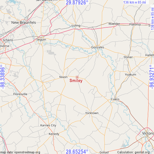
Smiley GPS coordinates[2]
29° 16' 3.864" North, 97° 38' 8.988" West
| Map corner | latitude | longitude |
|---|---|---|
| Upper-left | 29.87926°, | -98.33896° |
| Center: | 29.26774°, | -97.63583° |
| Lower-right: | 28.65254°, | -96.93271° |
| Map W x H: | 136.4×136.4 km | = 84.8×84.8mi |
| max Lat: | 71.29058° ⇑95% North |
| Smiley: | 29.26774° |
| min Lat: | ⇓5% South 19.06759° |
| min Long | Smiley | max Long |
| -171.73463° | -97.63583° | -66.98998° |
| W 22.5%⇐ | ⇒77.5% E |
Elevation
Elevation of Smiley is 100 m = 328 ft, and this is 194.8 m = 639 ft below average elevation for this country.
| Max E: |
3189 m = 10463 ft | 70.1% |
| Avg. | 294.8 m = 967 ft | |
| Smiley | 100 m = 328 ft | |
Min E: |
-60 m = -197 ft | 29.9% |
See also: United States elevation on elevation.city.
Geographical zone
Smiley is located in North temperate zone (between Tropic of Cancer and the Arctic Circle). Distance of this Northern Tropic circle is 648.3 km =402.8 mi to South.| Distance of | km | miles | from Smiley |
|---|---|---|---|
| North Pole | 6752.8 | 4196 | to North |
| Arctic Circle | 4146.9 | 2576.8 | to North |
| Tropic Cancer | 648.3 | 402.8 | to South |
| Equator | 3254.3 | 2022.1 | to South |


Nearby cities:
15 places around Smiley: (largest is in red/bold)
• Cuero
38.8 km =24.1 mi,  119°
119°
• Falls City
48.8 km =30.3 mi,  229°
229°
• Gonzales
31.5 km =19.6 mi,  34°
34°
• Karnes City
49.7 km =30.9 mi,  211°
211°
• Kingsbury
46.2 km =28.7 mi,  336°
336°
• La Vernia
47.5 km =29.5 mi,  281°
281°
• Luling
45.9 km =28.5 mi,  358°
358°
• Nixon
12.5 km =7.8 mi,  269°
269°
• Poth
48.6 km =30.2 mi,  243°
243°
• Runge
43.4 km =27 mi,  189°
189°
• Seguin
46.2 km =28.7 mi,  316°
316°
• Shiner
48.5 km =30.1 mi,  68°
68°
• Stockdale
31.6 km =19.6 mi,  263°
263°
• Yoakum
47 km =29.2 mi,  87°
87°
• Yorktown
34.4 km =21.4 mi,  157°
157°
Sources, notices
• [Note1] Compared only with cities in United States existing in our database
• [Src1] Map data: © OpenStreetMap contributors (CC-BY-SA)
• [Src2] Other city data from geonames.org with taken over terms of usage.
• [Src3] Geographical zone / Annual Mean Temperature by Robert A. Rohde @ Wikipedia
