Lockhart geodata
Lockhart (Texas) is a seat of a second-order administrative division; located in United States in America/Chicago (GMT-5) time zone. With population of 13,446 people, there are 3568 cities with bigger population in this country. Compared to other cities in United States, 93.7% of cities are located further ↑North; 77.6% of cities are located further →East and 59% of cities have higher elevation than Lockhart. Note1


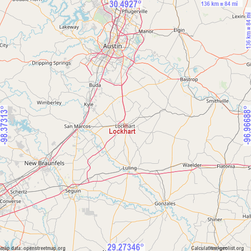
Lockhart GPS coordinates[2]
29° 53' 5.784" North, 97° 40' 12" West
| Map corner | latitude | longitude |
|---|---|---|
| Upper-left | 30.4927°, | -98.37313° |
| Center: | 29.88494°, | -97.67° |
| Lower-right: | 29.27346°, | -96.96688° |
| Map W x H: | 135.6×135.6 km | = 84.3×84.3mi |
| max Lat: | 71.29058° ⇑93.7% North |
| Lockhart: | 29.88494° |
| min Lat: | ⇓6.3% South 19.06759° |
| min Long | Lockhart | max Long |
| -171.73463° | -97.67° | -66.98998° |
| W 22.4%⇐ | ⇒77.6% E |
Elevation
Elevation of Lockhart is 160 m = 525 ft, and this is 134.8 m = 442 ft below average elevation for this country.
| Max E: |
3189 m = 10463 ft | 59% |
| Avg. | 294.8 m = 967 ft | |
| Lockhart | 160 m = 525 ft | |
Min E: |
-60 m = -197 ft | 41% |
See also: United States elevation on elevation.city.
Geographical zone
Lockhart is located in North temperate zone (between Tropic of Cancer and the Arctic Circle). Distance of this Northern Tropic circle is 717 km =445.5 mi to South.| Distance of | km | miles | from Lockhart |
|---|---|---|---|
| North Pole | 6684.2 | 4153.4 | to North |
| Arctic Circle | 4078.3 | 2534.1 | to North |
| Tropic Cancer | 717 | 445.5 | to South |
| Equator | 3322.9 | 2064.8 | to South |


Nearby cities:
15 places around Lockhart: (largest is in red/bold)
• Buda
27.7 km =17.2 mi,  323°
323°
• Kingsbury
30.4 km =18.9 mi,  210°
210°
• Kyle
23.1 km =14.4 mi,  300°
300°
• Luling
22.8 km =14.2 mi,  174°
174°
• Manchaca
32.5 km =20.2 mi,  331°
331°
• Martindale
17 km =10.6 mi,  255°
255°
• Mountain City
26.9 km =16.7 mi,  309°
309°
• Mustang Ridge
19.2 km =11.9 mi,  353°
353°
• Niederwald
14.9 km =9.3 mi,  337°
337°
• Onion Creek
30.1 km =18.7 mi, 338°
• Redwood
24.7 km =15.3 mi,  250°
250°
• San Leanna
32.3 km =20.1 mi, 333°
• San Marcos
26.2 km =16.3 mi,  269°
269°
• Uhland
13.8 km =8.6 mi, 305°
• Wyldwood
33.2 km =20.6 mi,  34°
34°
Sources, notices
• [Note1] Compared only with cities in United States existing in our database
• [Src1] Map data: © OpenStreetMap contributors (CC-BY-SA)
• [Src2] Other city data from geonames.org with taken over terms of usage.
• [Src3] Geographical zone / Annual Mean Temperature by Robert A. Rohde @ Wikipedia
