Mineral Wells geodata
Mineral Wells (Texas) is a populated place; located in United States in America/Chicago (GMT-5) time zone. With population of 14,754 people, there are 3288 cities with bigger population in this country. Compared to other cities in United States, 85.9% of cities are located further ↑North; 78.7% of cities are located further →East and 67.4% of cities have lower elevation than Mineral Wells. Note1


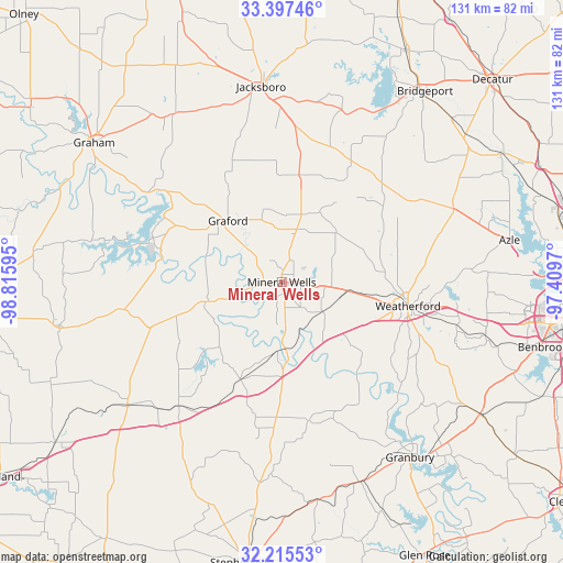
Mineral Wells GPS coordinates[2]
32° 48' 30.456" North, 98° 6' 46.152" West
| Map corner | latitude | longitude |
|---|---|---|
| Upper-left | 33.39746°, | -98.81595° |
| Center: | 32.80846°, | -98.11282° |
| Lower-right: | 32.21553°, | -97.4097° |
| Map W x H: | 131.4×131.4 km | = 81.6×81.6mi |
| max Lat: | 71.29058° ⇑85.9% North |
| Mineral Wells: | 32.80846° |
| min Lat: | ⇓14.1% South 19.06759° |
| min Long | Mineral Wells | max Long |
| -171.73463° | -98.11282° | -66.98998° |
| W 21.3%⇐ | ⇒78.7% E |
Elevation
Elevation of Mineral Wells is 273 m = 896 ft, and this is 21.8 m = 72 ft below average elevation for this country.
| Max E: |
3189 m = 10463 ft | 32.6% |
| Avg. | 294.8 m = 967 ft | |
| Mineral Wells | 273 m = 896 ft | |
Min E: |
-60 m = -197 ft | 67.4% |
See also: United States elevation on elevation.city.
Geographical zone
Mineral Wells is located in North temperate zone (between Tropic of Cancer and the Arctic Circle). Distance of this Northern Tropic circle is 1042 km =647.5 mi to South.| Distance of | km | miles | from Mineral Wells |
|---|---|---|---|
| North Pole | 6359.1 | 3951.4 | to North |
| Arctic Circle | 3753.2 | 2332.1 | to North |
| Tropic Cancer | 1042 | 647.5 | to South |
| Equator | 3648 | 2266.8 | to South |


Nearby cities:
15 places around Mineral Wells: (largest is in red/bold)
• Annetta
42.3 km =26.3 mi,  105°
105°
• Annetta North
42 km =26.1 mi,  103°
103°
• Annetta South
45.1 km =28 mi, 110°
• Bryson
46.8 km =29.1 mi,  327°
327°
• Graford
19.1 km =11.9 mi,  318°
318°
• Hudson Oaks
38.4 km =23.9 mi, 98°
• Jacksboro
45.8 km =28.5 mi,  354°
354°
• Oak Trail Shores
44.1 km =27.4 mi,  143°
143°
• Palo Pinto
18 km =11.2 mi,  255°
255°
• Runaway Bay
45.6 km =28.3 mi,  28°
28°
• Springtown
43.7 km =27.2 mi,  66°
66°
• Strawn
46 km =28.6 mi,  231°
231°
• Weatherford
30 km =18.6 mi, 100°
• Western Lake
34.9 km =21.7 mi,  126°
126°
• Willow Park
43.5 km =27 mi, 96°
Sources, notices
• [Note1] Compared only with cities in United States existing in our database
• [Src1] Map data: © OpenStreetMap contributors (CC-BY-SA)
• [Src2] Other city data from geonames.org with taken over terms of usage.
• [Src3] Geographical zone / Annual Mean Temperature by Robert A. Rohde @ Wikipedia
