Wolfe City geodata
Wolfe City (Texas) is a populated place; located in United States in America/Chicago (GMT-5) time zone. With population of 1,416 people, there are 14034 cities with bigger population in this country. Compared to other cities in United States, 83.7% of cities are located further ↑North; 73.6% of cities are located further →East and 54.2% of cities have lower elevation than Wolfe City. Note1


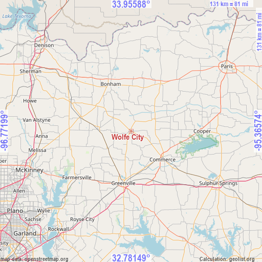
Wolfe City GPS coordinates[2]
33° 22' 14.412" North, 96° 4' 7.896" West
| Map corner | latitude | longitude |
|---|---|---|
| Upper-left | 33.95588°, | -96.77199° |
| Center: | 33.37067°, | -96.06886° |
| Lower-right: | 32.78149°, | -95.36574° |
| Map W x H: | 130.6×130.6 km | = 81.2×81.2mi |
| max Lat: | 71.29058° ⇑83.7% North |
| Wolfe City: | 33.37067° |
| min Lat: | ⇓16.3% South 19.06759° |
| min Long | Wolfe City | max Long |
| -171.73463° | -96.06886° | -66.98998° |
| W 26.4%⇐ | ⇒73.6% E |
Elevation
Elevation of Wolfe City is 215 m = 705 ft, and this is 79.8 m = 262 ft below average elevation for this country.
| Max E: |
3189 m = 10463 ft | 45.8% |
| Avg. | 294.8 m = 967 ft | |
| Wolfe City | 215 m = 705 ft | |
Min E: |
-60 m = -197 ft | 54.2% |
See also: United States elevation on elevation.city.
Geographical zone
Wolfe City is located in North temperate zone (between Tropic of Cancer and the Arctic Circle). Distance of this Northern Tropic circle is 1104.6 km =686.4 mi to South.| Distance of | km | miles | from Wolfe City |
|---|---|---|---|
| North Pole | 6296.6 | 3912.5 | to North |
| Arctic Circle | 3690.7 | 2293.3 | to North |
| Tropic Cancer | 1104.6 | 686.4 | to South |
| Equator | 3710.5 | 2305.6 | to South |


Nearby cities:
15 places around Wolfe City: (largest is in red/bold)
• Blue Ridge
32 km =19.9 mi,  255°
255°
• Bonham
25.1 km =15.6 mi,  336°
336°
• Campbell
27 km =16.8 mi,  156°
156°
• Celeste
14.5 km =9 mi,  233°
233°
• Commerce
20.9 km =13 mi,  131°
131°
• Cooper
35.3 km =21.9 mi,  89°
89°
• Cumby
33.6 km =20.9 mi,  140°
140°
• Ector
29.8 km =18.5 mi,  320°
320°
• Farmersville
35.5 km =22.1 mi, 229°
• Greenville
26.1 km =16.2 mi,  188°
188°
• Honey Grove
27.9 km =17.3 mi,  31°
31°
• Ladonia
12.9 km =8 mi,  62°
62°
• Leonard
16.6 km =10.3 mi,  273°
273°
• Trenton
25.9 km =16.1 mi,  284°
284°
• Whitewright
33.9 km =21.1 mi,  297°
297°
Sources, notices
• [Note1] Compared only with cities in United States existing in our database
• [Src1] Map data: © OpenStreetMap contributors (CC-BY-SA)
• [Src2] Other city data from geonames.org with taken over terms of usage.
• [Src3] Geographical zone / Annual Mean Temperature by Robert A. Rohde @ Wikipedia
