Cooper geodata
Cooper (Texas) is a seat of a second-order administrative division; located in United States in America/Chicago (GMT-5) time zone. With population of 1,957 people, there are 12069 cities with bigger population in this country. Compared to other cities in United States, 83.7% of cities are located further ↑North; 72.8% of cities are located further →East and 60.1% of cities have higher elevation than Cooper. Note1


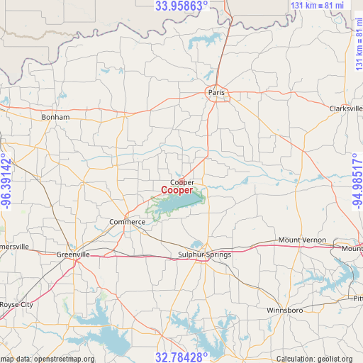
Cooper GPS coordinates[2]
33° 22' 24.384" North, 95° 41' 17.844" West
| Map corner | latitude | longitude |
|---|---|---|
| Upper-left | 33.95863°, | -96.39142° |
| Center: | 33.37344°, | -95.68829° |
| Lower-right: | 32.78428°, | -94.98517° |
| Map W x H: | 130.6×130.6 km | = 81.2×81.2mi |
| max Lat: | 71.29058° ⇑83.7% North |
| Cooper: | 33.37344° |
| min Lat: | ⇓16.3% South 19.06759° |
| min Long | Cooper | max Long |
| -171.73463° | -95.68829° | -66.98998° |
| W 27.2%⇐ | ⇒72.8% E |
Elevation
Elevation of Cooper is 154 m = 505 ft, and this is 140.8 m = 462 ft below average elevation for this country.
| Max E: |
3189 m = 10463 ft | 60.1% |
| Avg. | 294.8 m = 967 ft | |
| Cooper | 154 m = 505 ft | |
Min E: |
-60 m = -197 ft | 39.9% |
See also: United States elevation on elevation.city.
Geographical zone
Cooper is located in North temperate zone (between Tropic of Cancer and the Arctic Circle). Distance of this Northern Tropic circle is 1104.9 km =686.6 mi to South.| Distance of | km | miles | from Cooper |
|---|---|---|---|
| North Pole | 6296.3 | 3912.3 | to North |
| Arctic Circle | 3690.4 | 2293.1 | to North |
| Tropic Cancer | 1104.9 | 686.6 | to South |
| Equator | 3710.8 | 2305.8 | to South |


Nearby cities:
15 places around Cooper: (largest is in red/bold)
• Blossom
42.6 km =26.5 mi,  41°
41°
• Bogata
45.3 km =28.1 mi,  76°
76°
• Campbell
35 km =21.7 mi,  224°
224°
• Commerce
24.2 km =15 mi,  234°
234°
• Como
40.2 km =25 mi,  149°
149°
• Cumby
29.8 km =18.5 mi,  208°
208°
• Deport
38.5 km =23.9 mi,  63°
63°
• Honey Grove
31.1 km =19.3 mi,  318°
318°
• Ladonia
24.6 km =15.3 mi,  283°
283°
• Paris
34.3 km =21.3 mi,  21°
21°
• Pine Forest
40.5 km =25.2 mi,  135°
135°
• Reno
38.4 km =23.9 mi,  33°
33°
• Roxton
19.5 km =12.1 mi,  349°
349°
• Sulphur Springs
27.4 km =17 mi,  162°
162°
• Wolfe City
35.3 km =21.9 mi,  269°
269°
Sources, notices
• [Note1] Compared only with cities in United States existing in our database
• [Src1] Map data: © OpenStreetMap contributors (CC-BY-SA)
• [Src2] Other city data from geonames.org with taken over terms of usage.
• [Src3] Geographical zone / Annual Mean Temperature by Robert A. Rohde @ Wikipedia
