Honey Grove geodata
Honey Grove (Texas) is a populated place; located in United States in America/Chicago (GMT-5) time zone. With population of 1,656 people, there are 13063 cities with bigger population in this country. Compared to other cities in United States, 82.7% of cities are located further ↑North; 73.2% of cities are located further →East and 52.8% of cities have lower elevation than Honey Grove. Note1


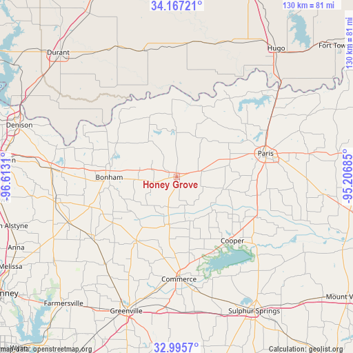
Honey Grove GPS coordinates[2]
33° 35' 0.384" North, 95° 54' 35.892" West
| Map corner | latitude | longitude |
|---|---|---|
| Upper-left | 34.16721°, | -96.6131° |
| Center: | 33.58344°, | -95.90997° |
| Lower-right: | 32.9957°, | -95.20685° |
| Map W x H: | 130.3×130.3 km | = 81×81mi |
| max Lat: | 71.29058° ⇑82.7% North |
| Honey Grove: | 33.58344° |
| min Lat: | ⇓17.3% South 19.06759° |
| min Long | Honey Grove | max Long |
| -171.73463° | -95.90997° | -66.98998° |
| W 26.8%⇐ | ⇒73.2% E |
Elevation
Elevation of Honey Grove is 209 m = 686 ft, and this is 85.8 m = 281 ft below average elevation for this country.
| Max E: |
3189 m = 10463 ft | 47.2% |
| Avg. | 294.8 m = 967 ft | |
| Honey Grove | 209 m = 686 ft | |
Min E: |
-60 m = -197 ft | 52.8% |
See also: United States elevation on elevation.city.
Geographical zone
Honey Grove is located in North temperate zone (between Tropic of Cancer and the Arctic Circle). Distance of this Northern Tropic circle is 1128.2 km =701 mi to South.| Distance of | km | miles | from Honey Grove |
|---|---|---|---|
| North Pole | 6272.9 | 3897.8 | to North |
| Arctic Circle | 3667 | 2278.6 | to North |
| Tropic Cancer | 1128.2 | 701 | to South |
| Equator | 3734.1 | 2320.3 | to South |


Nearby cities:
15 places around Honey Grove: (largest is in red/bold)
• Bonham
24.9 km =15.5 mi,  268°
268°
• Celeste
41.6 km =25.8 mi,  219°
219°
• Commerce
37.4 km =23.2 mi,  178°
178°
• Cooper
31.1 km =19.3 mi,  138°
138°
• Ector
33.7 km =20.9 mi, 268°
• Ladonia
18 km =11.2 mi,  190°
190°
• Leonard
38.6 km =24 mi,  234°
234°
• Paris
33.9 km =21.1 mi,  75°
75°
• Powderly
43.7 km =27.2 mi,  54°
54°
• Reno
42.4 km =26.3 mi, 77°
• Roxton
17.6 km =10.9 mi,  103°
103°
• Savoy
42.3 km =26.3 mi, 272°
• Trenton
43.2 km =26.8 mi,  246°
246°
• Whitewright
45.4 km =28.2 mi,  260°
260°
• Wolfe City
27.9 km =17.3 mi,  211°
211°
Sources, notices
• [Note1] Compared only with cities in United States existing in our database
• [Src1] Map data: © OpenStreetMap contributors (CC-BY-SA)
• [Src2] Other city data from geonames.org with taken over terms of usage.
• [Src3] Geographical zone / Annual Mean Temperature by Robert A. Rohde @ Wikipedia
