Lebanon geodata
Lebanon (Virginia) is a seat of a second-order administrative division; located in United States in America/New_York (GMT-4) time zone. With population of 3,342 people, there are 9074 cities with bigger population in this country. Compared to other cities in United States, 66.6% of cities are located further ↑North; 65.3% of cities are located further ←West and 90% of cities have lower elevation than Lebanon. Note1


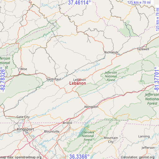
Lebanon GPS coordinates[2]
36° 54' 3.384" North, 82° 4' 48.468" West
| Map corner | latitude | longitude |
|---|---|---|
| Upper-left | 37.46114°, | -82.78326° |
| Center: | 36.90094°, | -82.08013° |
| Lower-right: | 36.3366°, | -81.37701° |
| Map W x H: | 125×125 km | = 77.7×77.7mi |
| max Lat: | 71.29058° ⇑66.6% North |
| Lebanon: | 36.90094° |
| min Lat: | ⇓33.4% South 19.06759° |
| min Long | Lebanon | max Long |
| -171.73463° | -82.08013° | -66.98998° |
| W 65.3%⇐ | ⇒34.7% E |
Elevation
Elevation of Lebanon is 627 m = 2057 ft, and this is 332.2 m = 1090 ft above average elevation for this country.
| Max E: |
3189 m = 10463 ft | 10% |
| Lebanon | 627 m 2057 ft | |
| Avg. | 294.8 m = 967 ft | |
Min E: |
-60 m = -197 ft | 90% |
See also: United States elevation on elevation.city.
Geographical zone
Lebanon is located in North temperate zone (between Tropic of Cancer and the Arctic Circle). Distance of this Northern Tropic circle is 1497.1 km =930.3 mi to South.| Distance of | km | miles | from Lebanon |
|---|---|---|---|
| North Pole | 5904.1 | 3668.6 | to North |
| Arctic Circle | 3298.2 | 2049.4 | to North |
| Tropic Cancer | 1497.1 | 930.3 | to South |
| Equator | 4103 | 2549.5 | to South |


Nearby cities:
15 places around Lebanon: (largest is in red/bold)
• Abingdon
23.1 km =14.4 mi,  156°
156°
• Bristol
35.2 km =21.9 mi,  195°
195°
• Castlewood
17.8 km =11.1 mi,  266°
266°
• Cedar Bluff
35.3 km =21.9 mi,  53°
53°
• Claypool Hill
34.3 km =21.3 mi,  58°
58°
• Coeburn
34.5 km =21.4 mi,  277°
277°
• Dante
21.2 km =13.2 mi,  294°
294°
• Emory
26 km =16.2 mi,  123°
123°
• Glade Spring
30.1 km =18.7 mi,  113°
113°
• Honaker
15.9 km =9.9 mi,  36°
36°
• Meadowview
24.9 km =15.5 mi,  128°
128°
• Raven
28.8 km =17.9 mi, 43°
• Richlands
33.2 km =20.6 mi, 49°
• Saint Paul
20.5 km =12.7 mi, 271°
• Saltville
28.4 km =17.6 mi,  94°
94°
Sources, notices
• [Note1] Compared only with cities in United States existing in our database
• [Src1] Map data: © OpenStreetMap contributors (CC-BY-SA)
• [Src2] Other city data from geonames.org with taken over terms of usage.
• [Src3] Geographical zone / Annual Mean Temperature by Robert A. Rohde @ Wikipedia
