Castlewood geodata
Castlewood (Virginia) is a populated place; located in United States in America/New_York (GMT-4) time zone. With population of 2,045 people, there are 11809 cities with bigger population in this country. Compared to other cities in United States, 66.6% of cities are located further ↑North; 64.7% of cities are located further ←West and 87.6% of cities have lower elevation than Castlewood. Note1


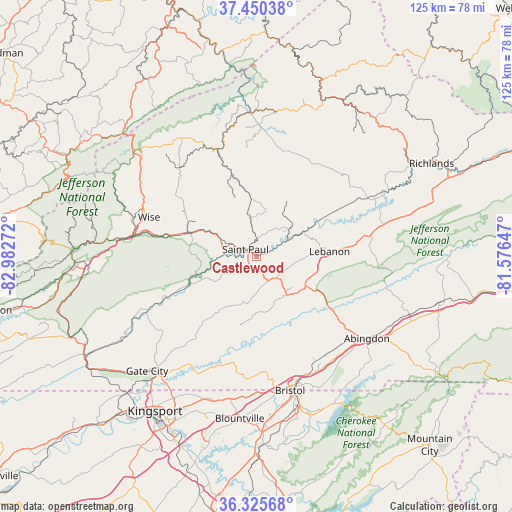
Castlewood GPS coordinates[2]
36° 53' 24.36" North, 82° 16' 46.524" West
| Map corner | latitude | longitude |
|---|---|---|
| Upper-left | 37.45038°, | -82.98272° |
| Center: | 36.8901°, | -82.27959° |
| Lower-right: | 36.32568°, | -81.57647° |
| Map W x H: | 125.1×125.1 km | = 77.7×77.7mi |
| max Lat: | 71.29058° ⇑66.6% North |
| Castlewood: | 36.8901° |
| min Lat: | ⇓33.4% South 19.06759° |
| min Long | Castlewood | max Long |
| -171.73463° | -82.27959° | -66.98998° |
| W 64.7%⇐ | ⇒35.3% E |
Elevation
Elevation of Castlewood is 491 m = 1611 ft, and this is 196.2 m = 644 ft above average elevation for this country.
| Max E: |
3189 m = 10463 ft | 12.4% |
| Castlewood | 491 m 1611 ft | |
| Avg. | 294.8 m = 967 ft | |
Min E: |
-60 m = -197 ft | 87.6% |
See also: United States elevation on elevation.city.
Geographical zone
Castlewood is located in North temperate zone (between Tropic of Cancer and the Arctic Circle). Distance of this Northern Tropic circle is 1495.9 km =929.5 mi to South.| Distance of | km | miles | from Castlewood |
|---|---|---|---|
| North Pole | 5905.3 | 3669.4 | to North |
| Arctic Circle | 3299.4 | 2050.2 | to North |
| Tropic Cancer | 1495.9 | 929.5 | to South |
| Equator | 4101.8 | 2548.7 | to South |


Nearby cities:
15 places around Castlewood: (largest is in red/bold)
• Abingdon
33.6 km =20.9 mi,  126°
126°
• Bristol
33.6 km =20.9 mi,  166°
166°
• Bristol
33.8 km =21 mi, 166°
• Clintwood
32.9 km =20.4 mi,  331°
331°
• Coeburn
17.5 km =10.9 mi,  290°
290°
• Dante
10 km =6.2 mi,  350°
350°
• Fairmount
35.3 km =21.9 mi,  164°
164°
• Honaker
30.5 km =19 mi,  62°
62°
• Lebanon
17.8 km =11.1 mi,  86°
86°
• Norton
31.4 km =19.5 mi,  278°
278°
• Pound
38.6 km =24 mi,  312°
312°
• Riverview
18.7 km =11.6 mi, 285°
• Saint Paul
3.3 km =2.1 mi,  301°
301°
• Walnut Hill
35.7 km =22.2 mi,  176°
176°
• Wise
28 km =17.4 mi, 289°
Sources, notices
• [Note1] Compared only with cities in United States existing in our database
• [Src1] Map data: © OpenStreetMap contributors (CC-BY-SA)
• [Src2] Other city data from geonames.org with taken over terms of usage.
• [Src3] Geographical zone / Annual Mean Temperature by Robert A. Rohde @ Wikipedia
