Ashburn geodata
Ashburn (Virginia) is a populated place; located in United States in America/New_York (GMT-4) time zone. With population of 43,511 people, there are 1097 cities with bigger population in this country. Compared to other cities in United States, 54.4% of cities are located further ↑North; 79% of cities are located further ←West and 72% of cities have higher elevation than Ashburn. Note1


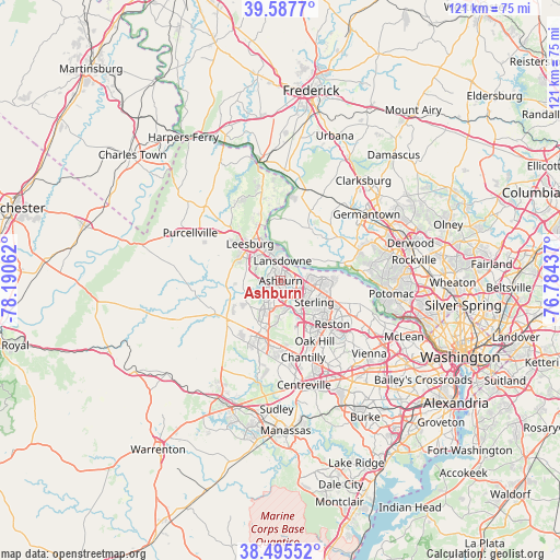
Ashburn GPS coordinates[2]
39° 2' 37.392" North, 77° 29' 14.964" West
| Map corner | latitude | longitude |
|---|---|---|
| Upper-left | 39.5877°, | -78.19062° |
| Center: | 39.04372°, | -77.48749° |
| Lower-right: | 38.49552°, | -76.78437° |
| Map W x H: | 121.4×121.4 km | = 75.4×75.4mi |
| max Lat: | 71.29058° ⇑54.4% North |
| Ashburn: | 39.04372° |
| min Lat: | ⇓45.6% South 19.06759° |
| min Long | Ashburn | max Long |
| -171.73463° | -77.48749° | -66.98998° |
| W 79%⇐ | ⇒21% E |
Elevation
Elevation of Ashburn is 89 m = 292 ft, and this is 205.8 m = 675 ft below average elevation for this country.
| Max E: |
3189 m = 10463 ft | 72% |
| Avg. | 294.8 m = 967 ft | |
| Ashburn | 89 m = 292 ft | |
Min E: |
-60 m = -197 ft | 28% |
See also: Ashburn elevation on elevation.city.
Geographical zone
Ashburn is located in North temperate zone (between Tropic of Cancer and the Arctic Circle). Distance of this Northern Tropic circle is 1735.3 km =1078.3 mi to South.| Distance of | km | miles | from Ashburn |
|---|---|---|---|
| North Pole | 5665.8 | 3520.6 | to North |
| Arctic Circle | 3059.9 | 1901.3 | to North |
| Tropic Cancer | 1735.3 | 1078.3 | to South |
| Equator | 4341.3 | 2697.6 | to South |


Nearby cities:
15 places around Ashburn: (largest is in red/bold)
• Belmont
3 km =1.9 mi,  320°
320°
• Brambleton
8.2 km =5.1 mi,  212°
212°
• Broadlands
4 km =2.5 mi,  224°
224°
• Countryside
6.4 km =4 mi,  92°
92°
• Dranesville
13.1 km =8.1 mi,  111°
111°
• Dulles Town Center
6.2 km =3.9 mi,  96°
96°
• Herndon
12 km =7.5 mi,  133°
133°
• Leesburg
10.4 km =6.5 mi, 320°
• Loudoun Valley Estates
7.2 km =4.5 mi,  194°
194°
• Lowes Island
11.8 km =7.3 mi,  81°
81°
• Oak Grove
9.8 km =6.1 mi, 132°
• Poolesville
12.9 km =8 mi,  28°
28°
• Sterling
6.6 km =4.1 mi, 129°
• Sugarland Run
9.7 km =6 mi, 94°
• University Center
4 km =2.5 mi,  68°
68°
Sources, notices
• [Note1] Compared only with cities in United States existing in our database
• [Src1] Map data: © OpenStreetMap contributors (CC-BY-SA)
• [Src2] Other city data from geonames.org with taken over terms of usage.
• [Src3] Geographical zone / Annual Mean Temperature by Robert A. Rohde @ Wikipedia
