Leesburg geodata
Leesburg (Virginia) is a seat of a second-order administrative division; located in United States in America/New_York (GMT-4) time zone. With population of 51,209 people, there are 932 cities with bigger population in this country. Compared to other cities in United States, 53.8% of cities are located further ↑North; 78.8% of cities are located further ←West and 69.6% of cities have higher elevation than Leesburg. Note1


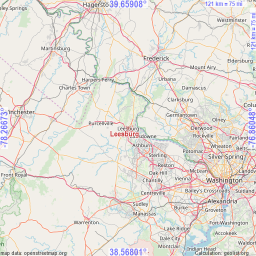
Leesburg GPS coordinates[2]
39° 6' 56.376" North, 77° 33' 48.96" West
| Map corner | latitude | longitude |
|---|---|---|
| Upper-left | 39.65908°, | -78.26673° |
| Center: | 39.11566°, | -77.5636° |
| Lower-right: | 38.56801°, | -76.86048° |
| Map W x H: | 121.3×121.3 km | = 75.4×75.4mi |
| max Lat: | 71.29058° ⇑53.8% North |
| Leesburg: | 39.11566° |
| min Lat: | ⇓46.2% South 19.06759° |
| min Long | Leesburg | max Long |
| -171.73463° | -77.5636° | -66.98998° |
| W 78.8%⇐ | ⇒21.2% E |
Elevation
Elevation of Leesburg is 103 m = 338 ft, and this is 191.8 m = 629 ft below average elevation for this country.
| Max E: |
3189 m = 10463 ft | 69.6% |
| Avg. | 294.8 m = 967 ft | |
| Leesburg | 103 m = 338 ft | |
Min E: |
-60 m = -197 ft | 30.4% |
See also: Leesburg elevation on elevation.city.
Geographical zone
Leesburg is located in North temperate zone (between Tropic of Cancer and the Arctic Circle). Distance of this Northern Tropic circle is 1743.3 km =1083.2 mi to South.| Distance of | km | miles | from Leesburg |
|---|---|---|---|
| North Pole | 5657.8 | 3515.6 | to North |
| Arctic Circle | 3051.9 | 1896.4 | to North |
| Tropic Cancer | 1743.3 | 1083.2 | to South |
| Equator | 4349.3 | 2702.5 | to South |


Nearby cities:
15 places around Leesburg: (largest is in red/bold)
• Ashburn
10.4 km =6.5 mi,  140°
140°
• Belmont
7.3 km =4.5 mi, 140°
• Brambleton
15 km =9.3 mi,  171°
171°
• Broadlands
11.5 km =7.1 mi,  160°
160°
• Countryside
15.4 km =9.6 mi,  122°
122°
• Dulles Town Center
15.4 km =9.6 mi, 124°
• Hamilton
8.8 km =5.5 mi,  283°
283°
• Loudoun Valley Estates
15.7 km =9.8 mi, 162°
• Point of Rocks
17.9 km =11.1 mi,  6°
6°
• Poolesville
13.1 km =8.1 mi,  75°
75°
• Purcellville
13.2 km =8.2 mi, 280°
• Round Hill
17.8 km =11.1 mi, 276°
• Sterling
16.8 km =10.4 mi, 136°
• Sugarland Run
18.4 km =11.4 mi, 118°
• University Center
12.2 km =7.6 mi, 122°
Sources, notices
• [Note1] Compared only with cities in United States existing in our database
• [Src1] Map data: © OpenStreetMap contributors (CC-BY-SA)
• [Src2] Other city data from geonames.org with taken over terms of usage.
• [Src3] Geographical zone / Annual Mean Temperature by Robert A. Rohde @ Wikipedia
