Belmont geodata
Belmont (Virginia) is a populated place; located in United States in America/New_York (GMT-4) time zone. With population of 5,966 people, there are 6432 cities with bigger population in this country. Compared to other cities in United States, 54.2% of cities are located further ↑North; 78.9% of cities are located further ←West and 71.7% of cities have higher elevation than Belmont. Note1


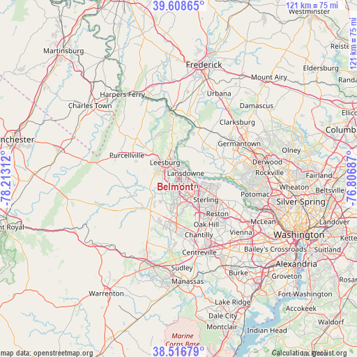
Belmont GPS coordinates[2]
39° 3' 53.388" North, 77° 30' 35.964" West
| Map corner | latitude | longitude |
|---|---|---|
| Upper-left | 39.60865°, | -78.21312° |
| Center: | 39.06483°, | -77.50999° |
| Lower-right: | 38.51679°, | -76.80687° |
| Map W x H: | 121.4×121.4 km | = 75.4×75.4mi |
| max Lat: | 71.29058° ⇑54.2% North |
| Belmont: | 39.06483° |
| min Lat: | ⇓45.8% South 19.06759° |
| min Long | Belmont | max Long |
| -171.73463° | -77.50999° | -66.98998° |
| W 78.9%⇐ | ⇒21.1% E |
Elevation
Elevation of Belmont is 91 m = 299 ft, and this is 203.8 m = 669 ft below average elevation for this country.
| Max E: |
3189 m = 10463 ft | 71.7% |
| Avg. | 294.8 m = 967 ft | |
| Belmont | 91 m = 299 ft | |
Min E: |
-60 m = -197 ft | 28.3% |
See also: United States elevation on elevation.city.
Geographical zone
Belmont is located in North temperate zone (between Tropic of Cancer and the Arctic Circle). Distance of this Northern Tropic circle is 1737.7 km =1079.8 mi to South.| Distance of | km | miles | from Belmont |
|---|---|---|---|
| North Pole | 5663.5 | 3519.1 | to North |
| Arctic Circle | 3057.6 | 1899.9 | to North |
| Tropic Cancer | 1737.7 | 1079.8 | to South |
| Equator | 4343.6 | 2699 | to South |


Nearby cities:
15 places around Belmont: (largest is in red/bold)
• Ashburn
3 km =1.9 mi,  140°
140°
• Brambleton
9.5 km =5.9 mi,  195°
195°
• Broadlands
5.3 km =3.3 mi,  189°
189°
• Countryside
8.7 km =5.4 mi,  107°
107°
• Dulles Town Center
8.7 km =5.4 mi, 110°
• Hamilton
15.3 km =9.5 mi,  300°
300°
• Herndon
15.1 km =9.4 mi,  134°
134°
• Leesburg
7.3 km =4.5 mi,  320°
320°
• Loudoun Valley Estates
9.3 km =5.8 mi,  178°
178°
• Lowes Island
13.6 km =8.5 mi,  92°
92°
• Oak Grove
12.8 km =8 mi, 134°
• Poolesville
12.1 km =7.5 mi,  41°
41°
• Sterling
9.6 km =6 mi, 132°
• Sugarland Run
12 km =7.5 mi,  104°
104°
• University Center
5.7 km =3.5 mi, 98°
Sources, notices
• [Note1] Compared only with cities in United States existing in our database
• [Src1] Map data: © OpenStreetMap contributors (CC-BY-SA)
• [Src2] Other city data from geonames.org with taken over terms of usage.
• [Src3] Geographical zone / Annual Mean Temperature by Robert A. Rohde @ Wikipedia
