Bedford geodata
Bedford (Virginia) is a seat of a second-order administrative division; located in United States in America/New_York (GMT-4) time zone. With population of 6,561 people, there are 6071 cities with bigger population in this country. Compared to other cities in United States, 64.7% of cities are located further ↑North; 74.8% of cities are located further ←West and 74% of cities have lower elevation than Bedford. Note1


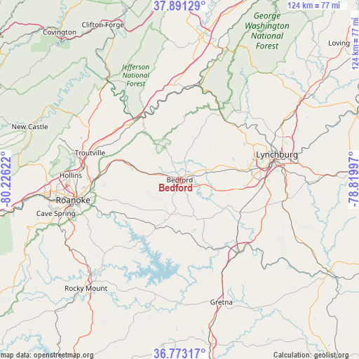
Bedford GPS coordinates[2]
37° 20' 3.516" North, 79° 31' 23.124" West
| Map corner | latitude | longitude |
|---|---|---|
| Upper-left | 37.89129°, | -80.22622° |
| Center: | 37.33431°, | -79.52309° |
| Lower-right: | 36.77317°, | -78.81997° |
| Map W x H: | 124.3×124.3 km | = 77.2×77.2mi |
| max Lat: | 71.29058° ⇑64.7% North |
| Bedford: | 37.33431° |
| min Lat: | ⇓35.3% South 19.06759° |
| min Long | Bedford | max Long |
| -171.73463° | -79.52309° | -66.98998° |
| W 74.8%⇐ | ⇒25.2% E |
Elevation
Elevation of Bedford is 307 m = 1007 ft, and this is 12.2 m = 40 ft above average elevation for this country.
| Max E: |
3189 m = 10463 ft | 26% |
| Bedford | 307 m 1007 ft | |
| Avg. | 294.8 m = 967 ft | |
Min E: |
-60 m = -197 ft | 74% |
See also: United States elevation on elevation.city.
Geographical zone
Bedford is located in North temperate zone (between Tropic of Cancer and the Arctic Circle). Distance of this Northern Tropic circle is 1545.3 km =960.2 mi to South.| Distance of | km | miles | from Bedford |
|---|---|---|---|
| North Pole | 5855.9 | 3638.7 | to North |
| Arctic Circle | 3250 | 2019.5 | to North |
| Tropic Cancer | 1545.3 | 960.2 | to South |
| Equator | 4151.2 | 2579.4 | to South |


Nearby cities:
15 places around Bedford: (largest is in red/bold)
• Altavista
32.5 km =20.2 mi,  139°
139°
• Blue Ridge
25.6 km =15.9 mi,  281°
281°
• Buchanan
25.5 km =15.8 mi,  327°
327°
• Cloverdale
34 km =21.1 mi, 275°
• Forest
20.9 km =13 mi,  80°
80°
• Glasgow
33.9 km =21.1 mi,  10°
10°
• Hurt
33.5 km =20.8 mi, 143°
• Laymantown
29.8 km =18.5 mi, 276°
• Montvale
19.2 km =11.9 mi,  286°
286°
• Motley
33.6 km =20.9 mi,  151°
151°
• North Shore
30.5 km =19 mi,  203°
203°
• Timberlake
23.5 km =14.6 mi,  93°
93°
• Vinton
33.6 km =20.9 mi,  259°
259°
• West Lynchburg
31.4 km =19.5 mi, 75°
• Westlake Corner
28.2 km =17.5 mi,  213°
213°
Sources, notices
• [Note1] Compared only with cities in United States existing in our database
• [Src1] Map data: © OpenStreetMap contributors (CC-BY-SA)
• [Src2] Other city data from geonames.org with taken over terms of usage.
• [Src3] Geographical zone / Annual Mean Temperature by Robert A. Rohde @ Wikipedia
