Westlake Corner geodata
Westlake Corner (Virginia) is a populated place; located in United States in America/New_York (GMT-4) time zone. With population of 976 people, there are 16446 cities with bigger population in this country. Compared to other cities in United States, 65.6% of cities are located further ↑North; 74.5% of cities are located further ←West and 70.1% of cities have lower elevation than Westlake Corner. Note1


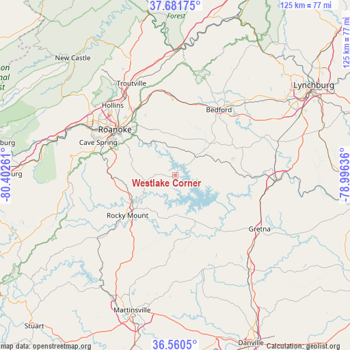
Westlake Corner GPS coordinates[2]
37° 7' 23.52" North, 79° 41' 58.128" West
| Map corner | latitude | longitude |
|---|---|---|
| Upper-left | 37.68175°, | -80.40261° |
| Center: | 37.1232°, | -79.69948° |
| Lower-right: | 36.5605°, | -78.99636° |
| Map W x H: | 124.7×124.7 km | = 77.5×77.5mi |
| max Lat: | 71.29058° ⇑65.6% North |
| Westlake Corner: | 37.1232° |
| min Lat: | ⇓34.4% South 19.06759° |
| min Long | Westlake Corner | max Long |
| -171.73463° | -79.69948° | -66.98998° |
| W 74.5%⇐ | ⇒25.5% E |
Elevation
Elevation of Westlake Corner is 286 m = 938 ft, and this is 8.8 m = 29 ft below average elevation for this country.
| Max E: |
3189 m = 10463 ft | 29.9% |
| Avg. | 294.8 m = 967 ft | |
| Westlake Corner | 286 m = 938 ft | |
Min E: |
-60 m = -197 ft | 70.1% |
See also: United States elevation on elevation.city.
Geographical zone
Westlake Corner is located in North temperate zone (between Tropic of Cancer and the Arctic Circle). Distance of this Northern Tropic circle is 1521.8 km =945.6 mi to South.| Distance of | km | miles | from Westlake Corner |
|---|---|---|---|
| North Pole | 5879.3 | 3653.2 | to North |
| Arctic Circle | 3273.5 | 2034.1 | to North |
| Tropic Cancer | 1521.8 | 945.6 | to South |
| Equator | 4127.7 | 2564.8 | to South |


Nearby cities:
15 places around Westlake Corner: (largest is in red/bold)
• Bedford
28.2 km =17.5 mi,  33°
33°
• Blue Ridge
29.9 km =18.6 mi,  341°
341°
• Cave Spring
30.1 km =18.7 mi,  292°
292°
• Cedar Bluff
26.1 km =16.2 mi,  306°
306°
• Henry Fork
23.1 km =14.4 mi,  220°
220°
• Laymantown
30.4 km =18.9 mi,  332°
332°
• Montvale
29.2 km =18.1 mi,  354°
354°
• Narrows
24.7 km =15.3 mi, 291°
• North Shore
5.8 km =3.6 mi,  141°
141°
• Penhook
16.9 km =10.5 mi,  157°
157°
• Ridgeway
24.3 km =15.1 mi,  127°
127°
• Roanoke
27 km =16.8 mi, 307°
• Rocky Mount
22.1 km =13.7 mi,  230°
230°
• Union Hall
11.7 km =7.3 mi,  174°
174°
• Vinton
24.8 km =15.4 mi,  315°
315°
Sources, notices
• [Note1] Compared only with cities in United States existing in our database
• [Src1] Map data: © OpenStreetMap contributors (CC-BY-SA)
• [Src2] Other city data from geonames.org with taken over terms of usage.
• [Src3] Geographical zone / Annual Mean Temperature by Robert A. Rohde @ Wikipedia
