Timberlake geodata
Timberlake (Virginia) is a populated place; located in United States in America/New_York (GMT-4) time zone. With population of 12,183 people, there are 3849 cities with bigger population in this country. Compared to other cities in United States, 64.8% of cities are located further ↑North; 75.3% of cities are located further ←West and 69.3% of cities have lower elevation than Timberlake. Note1


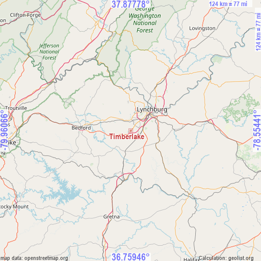
Timberlake GPS coordinates[2]
37° 19' 14.52" North, 79° 15' 27.108" West
| Map corner | latitude | longitude |
|---|---|---|
| Upper-left | 37.87778°, | -79.96066° |
| Center: | 37.3207°, | -79.25753° |
| Lower-right: | 36.75946°, | -78.55441° |
| Map W x H: | 124.3×124.3 km | = 77.2×77.2mi |
| max Lat: | 71.29058° ⇑64.8% North |
| Timberlake: | 37.3207° |
| min Lat: | ⇓35.2% South 19.06759° |
| min Long | Timberlake | max Long |
| -171.73463° | -79.25753° | -66.98998° |
| W 75.3%⇐ | ⇒24.7% E |
Elevation
Elevation of Timberlake is 282 m = 925 ft, and this is 12.8 m = 42 ft below average elevation for this country.
| Max E: |
3189 m = 10463 ft | 30.7% |
| Avg. | 294.8 m = 967 ft | |
| Timberlake | 282 m = 925 ft | |
Min E: |
-60 m = -197 ft | 69.3% |
See also: United States elevation on elevation.city.
Geographical zone
Timberlake is located in North temperate zone (between Tropic of Cancer and the Arctic Circle). Distance of this Northern Tropic circle is 1543.8 km =959.3 mi to South.| Distance of | km | miles | from Timberlake |
|---|---|---|---|
| North Pole | 5857.4 | 3639.6 | to North |
| Arctic Circle | 3251.5 | 2020.4 | to North |
| Tropic Cancer | 1543.8 | 959.3 | to South |
| Equator | 4149.7 | 2578.5 | to South |


Nearby cities:
15 places around Timberlake: (largest is in red/bold)
• Altavista
23.4 km =14.5 mi,  186°
186°
• Amherst
34.6 km =21.5 mi,  31°
31°
• Appomattox
38.4 km =23.9 mi,  83°
83°
• Bedford
23.5 km =14.6 mi,  273°
273°
• Brookneal
40.9 km =25.4 mi,  137°
137°
• Concord
25.1 km =15.6 mi, 84°
• Forest
5.6 km =3.5 mi,  329°
329°
• Glasgow
38.8 km =24.1 mi, 333°
• Gretna
41.8 km =26 mi, 192°
• Hurt
25.6 km =15.9 mi, 187°
• Lynchburg
14.5 km =9 mi,  44°
44°
• Madison Heights
17.1 km =10.6 mi, 44°
• Motley
28.9 km =18 mi, 194°
• Rustburg
14.7 km =9.1 mi,  109°
109°
• West Lynchburg
11.6 km =7.2 mi, 37°
Sources, notices
• [Note1] Compared only with cities in United States existing in our database
• [Src1] Map data: © OpenStreetMap contributors (CC-BY-SA)
• [Src2] Other city data from geonames.org with taken over terms of usage.
• [Src3] Geographical zone / Annual Mean Temperature by Robert A. Rohde @ Wikipedia
