Shawsville geodata
Shawsville (Virginia) is a populated place; located in United States in America/New_York (GMT-4) time zone. With population of 1,310 people, there are 14546 cities with bigger population in this country. Compared to other cities in United States, 65.4% of cities are located further ↑North; 71.9% of cities are located further ←West and 85.5% of cities have lower elevation than Shawsville. Note1


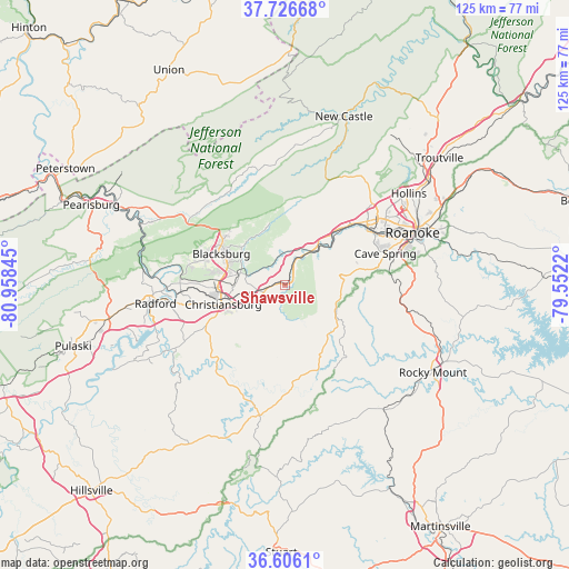
Shawsville GPS coordinates[2]
37° 10' 6.492" North, 80° 15' 19.152" West
| Map corner | latitude | longitude |
|---|---|---|
| Upper-left | 37.72668°, | -80.95845° |
| Center: | 37.16847°, | -80.25532° |
| Lower-right: | 36.6061°, | -79.5522° |
| Map W x H: | 124.6×124.6 km | = 77.4×77.4mi |
| max Lat: | 71.29058° ⇑65.4% North |
| Shawsville: | 37.16847° |
| min Lat: | ⇓34.6% South 19.06759° |
| min Long | Shawsville | max Long |
| -171.73463° | -80.25532° | -66.98998° |
| W 71.9%⇐ | ⇒28.1% E |
Elevation
Elevation of Shawsville is 433 m = 1421 ft, and this is 138.2 m = 453 ft above average elevation for this country.
| Max E: |
3189 m = 10463 ft | 14.5% |
| Shawsville | 433 m 1421 ft | |
| Avg. | 294.8 m = 967 ft | |
Min E: |
-60 m = -197 ft | 85.5% |
See also: United States elevation on elevation.city.
Geographical zone
Shawsville is located in North temperate zone (between Tropic of Cancer and the Arctic Circle). Distance of this Northern Tropic circle is 1526.8 km =948.7 mi to South.| Distance of | km | miles | from Shawsville |
|---|---|---|---|
| North Pole | 5874.3 | 3650.1 | to North |
| Arctic Circle | 3268.4 | 2030.9 | to North |
| Tropic Cancer | 1526.8 | 948.7 | to South |
| Equator | 4132.7 | 2567.9 | to South |


Nearby cities:
15 places around Shawsville: (largest is in red/bold)
• Blacksburg
15.6 km =9.7 mi,  295°
295°
• Cave Spring
22.5 km =14 mi,  72°
72°
• Christiansburg
14.3 km =8.9 mi,  252°
252°
• Elliston
5.7 km =3.5 mi,  20°
20°
• Fairlawn
28.7 km =17.8 mi,  265°
265°
• Floyd
29.2 km =18.1 mi,  191°
191°
• Glenvar
15.9 km =9.9 mi,  42°
42°
• Merrimac
15.3 km =9.5 mi,  278°
278°
• Narrows
26.6 km =16.5 mi,  81°
81°
• Plum Creek
22.2 km =13.8 mi,  258°
258°
• Prices Fork
21.3 km =13.2 mi, 282°
• Radford
28.8 km =17.9 mi, 261°
• Riner
20 km =12.4 mi,  235°
235°
• Salem
22.5 km =14 mi,  51°
51°
• Villa Heights
28.3 km =17.6 mi,  60°
60°
Sources, notices
• [Note1] Compared only with cities in United States existing in our database
• [Src1] Map data: © OpenStreetMap contributors (CC-BY-SA)
• [Src2] Other city data from geonames.org with taken over terms of usage.
• [Src3] Geographical zone / Annual Mean Temperature by Robert A. Rohde @ Wikipedia
