Bowling Green geodata
Bowling Green (Virginia) is a seat of a second-order administrative division; located in United States in America/New_York (GMT-4) time zone. With population of 1,160 people, there are 15332 cities with bigger population in this country. Compared to other cities in United States, 61.3% of cities are located further ↑North; 79.4% of cities are located further ←West and 75.1% of cities have higher elevation than Bowling Green. Note1


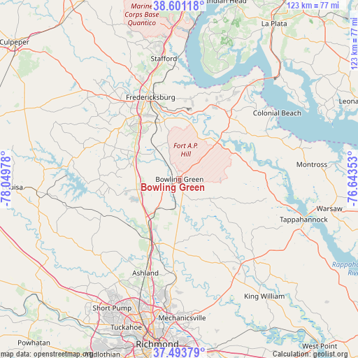
Bowling Green GPS coordinates[2]
38° 2' 58.488" North, 77° 20' 47.94" West
| Map corner | latitude | longitude |
|---|---|---|
| Upper-left | 38.60118°, | -78.04978° |
| Center: | 38.04958°, | -77.34665° |
| Lower-right: | 37.49379°, | -76.64353° |
| Map W x H: | 123.1×123.1 km | = 76.5×76.5mi |
| max Lat: | 71.29058° ⇑61.3% North |
| Bowling Green: | 38.04958° |
| min Lat: | ⇓38.7% South 19.06759° |
| min Long | Bowling Green | max Long |
| -171.73463° | -77.34665° | -66.98998° |
| W 79.4%⇐ | ⇒20.6% E |
Elevation
Elevation of Bowling Green is 71 m = 233 ft, and this is 223.8 m = 734 ft below average elevation for this country.
| Max E: |
3189 m = 10463 ft | 75.1% |
| Avg. | 294.8 m = 967 ft | |
| Bowling Green | 71 m = 233 ft | |
Min E: |
-60 m = -197 ft | 24.9% |
See also: United States elevation on elevation.city.
Geographical zone
Bowling Green is located in North temperate zone (between Tropic of Cancer and the Arctic Circle). Distance of this Northern Tropic circle is 1624.8 km =1009.6 mi to South.| Distance of | km | miles | from Bowling Green |
|---|---|---|---|
| North Pole | 5776.3 | 3589.2 | to North |
| Arctic Circle | 3170.5 | 1970.1 | to North |
| Tropic Cancer | 1624.8 | 1009.6 | to South |
| Equator | 4230.7 | 2628.8 | to South |


Nearby cities:
15 places around Bowling Green: (largest is in red/bold)
• Ashland
34.4 km =21.4 mi,  199°
199°
• Central Garage
38.9 km =24.2 mi,  150°
150°
• Colonial Beach
40.5 km =25.2 mi,  55°
55°
• Dahlgren
40.6 km =25.2 mi,  39°
39°
• Falmouth
32.3 km =20.1 mi,  340°
340°
• Fredericksburg
29.9 km =18.6 mi, 340°
• Glen Allen
44.9 km =27.9 mi, 198°
• Hanover
31.5 km =19.6 mi,  183°
183°
• King George
28.1 km =17.5 mi,  30°
30°
• Passapatanzy
27.7 km =17.2 mi,  5°
5°
• Southern Gateway
35.6 km =22.1 mi, 337°
• Spotsylvania
27.1 km =16.8 mi,  308°
308°
• Spotsylvania Courthouse
26.8 km =16.7 mi, 308°
• Stafford
41.8 km =26 mi,  352°
352°
• Tappahannock
44.9 km =27.9 mi,  107°
107°
Sources, notices
• [Note1] Compared only with cities in United States existing in our database
• [Src1] Map data: © OpenStreetMap contributors (CC-BY-SA)
• [Src2] Other city data from geonames.org with taken over terms of usage.
• [Src3] Geographical zone / Annual Mean Temperature by Robert A. Rohde @ Wikipedia
