Cedar Bluff geodata
Cedar Bluff (Virginia) is a populated place; located in United States in America/New_York (GMT-4) time zone. With population of 1,076 people, there are 15807 cities with bigger population in this country. Compared to other cities in United States, 65.7% of cities are located further ↑North; 66.5% of cities are located further ←West and 89.7% of cities have lower elevation than Cedar Bluff. Note1


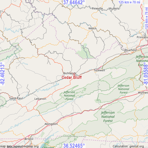
Cedar Bluff GPS coordinates[2]
37° 5' 15.396" North, 81° 45' 32.4" West
| Map corner | latitude | longitude |
|---|---|---|
| Upper-left | 37.64642°, | -82.46213° |
| Center: | 37.08761°, | -81.759° |
| Lower-right: | 36.52465°, | -81.05588° |
| Map W x H: | 124.7×124.7 km | = 77.5×77.5mi |
| max Lat: | 71.29058° ⇑65.7% North |
| Cedar Bluff: | 37.08761° |
| min Lat: | ⇓34.3% South 19.06759° |
| min Long | Cedar Bluff | max Long |
| -171.73463° | -81.759° | -66.98998° |
| W 66.5%⇐ | ⇒33.5% E |
Elevation
Elevation of Cedar Bluff is 601 m = 1972 ft, and this is 306.2 m = 1005 ft above average elevation for this country.
| Max E: |
3189 m = 10463 ft | 10.3% |
| Cedar Bluff | 601 m 1972 ft | |
| Avg. | 294.8 m = 967 ft | |
Min E: |
-60 m = -197 ft | 89.7% |
See also: United States elevation on elevation.city.
Geographical zone
Cedar Bluff is located in North temperate zone (between Tropic of Cancer and the Arctic Circle). Distance of this Northern Tropic circle is 1517.8 km =943.1 mi to South.| Distance of | km | miles | from Cedar Bluff |
|---|---|---|---|
| North Pole | 5883.3 | 3655.7 | to North |
| Arctic Circle | 3277.4 | 2036.5 | to North |
| Tropic Cancer | 1517.8 | 943.1 | to South |
| Equator | 4123.8 | 2562.4 | to South |


Nearby cities:
15 places around Cedar Bluff: (largest is in red/bold)
• Chilhowie
32.9 km =20.4 mi,  168°
168°
• Claypool Hill
2.9 km =1.8 mi, 167°
• Emory
35.7 km =22.2 mi,  191°
191°
• Glade Spring
33 km =20.5 mi,  181°
181°
• Gratton
31 km =19.3 mi,  80°
80°
• Honaker
20.7 km =12.9 mi,  247°
247°
• Lebanon
35.3 km =21.9 mi,  233°
233°
• Marion
35.5 km =22.1 mi,  142°
142°
• Raven
8.5 km =5.3 mi,  269°
269°
• Richlands
3.1 km =1.9 mi,  281°
281°
• Saltville
22.9 km =14.2 mi, 180°
• Seven Mile Ford
32.9 km =20.4 mi,  159°
159°
• Springville
33.8 km =21 mi,  69°
69°
• Tazewell
21.4 km =13.3 mi, 81°
• War
24.5 km =15.2 mi,  14°
14°
Sources, notices
• [Note1] Compared only with cities in United States existing in our database
• [Src1] Map data: © OpenStreetMap contributors (CC-BY-SA)
• [Src2] Other city data from geonames.org with taken over terms of usage.
• [Src3] Geographical zone / Annual Mean Temperature by Robert A. Rohde @ Wikipedia
