Tazewell geodata
Tazewell (Virginia) is a seat of a second-order administrative division; located in United States in America/New_York (GMT-4) time zone. With population of 4,421 people, there are 7724 cities with bigger population in this country. Compared to other cities in United States, 65.6% of cities are located further ↑North; 67.5% of cities are located further ←West and 91.6% of cities have lower elevation than Tazewell. Note1


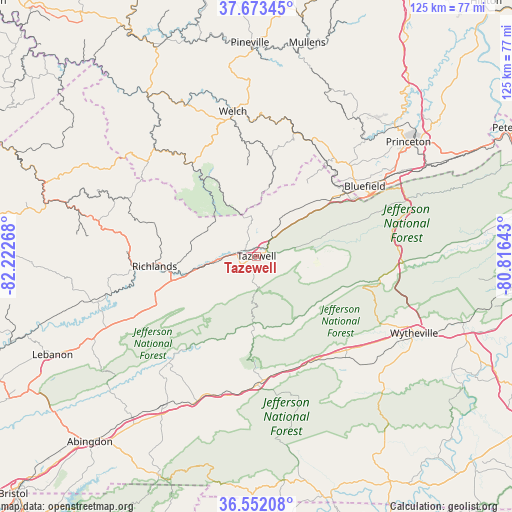
Tazewell GPS coordinates[2]
37° 6' 53.424" North, 81° 31' 10.38" West
| Map corner | latitude | longitude |
|---|---|---|
| Upper-left | 37.67345°, | -82.22268° |
| Center: | 37.11484°, | -81.51955° |
| Lower-right: | 36.55208°, | -80.81643° |
| Map W x H: | 124.7×124.7 km | = 77.5×77.5mi |
| max Lat: | 71.29058° ⇑65.6% North |
| Tazewell: | 37.11484° |
| min Lat: | ⇓34.4% South 19.06759° |
| min Long | Tazewell | max Long |
| -171.73463° | -81.51955° | -66.98998° |
| W 67.5%⇐ | ⇒32.5% E |
Elevation
Elevation of Tazewell is 764 m = 2507 ft, and this is 469.2 m = 1539 ft above average elevation for this country.
| Max E: |
3189 m = 10463 ft | 8.4% |
| Tazewell | 764 m 2507 ft | |
| Avg. | 294.8 m = 967 ft | |
Min E: |
-60 m = -197 ft | 91.6% |
See also: United States elevation on elevation.city.
Geographical zone
Tazewell is located in North temperate zone (between Tropic of Cancer and the Arctic Circle). Distance of this Northern Tropic circle is 1520.9 km =945 mi to South.| Distance of | km | miles | from Tazewell |
|---|---|---|---|
| North Pole | 5880.3 | 3653.8 | to North |
| Arctic Circle | 3274.4 | 2034.6 | to North |
| Tropic Cancer | 1520.9 | 945 | to South |
| Equator | 4126.8 | 2564.3 | to South |


Nearby cities:
15 places around Tazewell: (largest is in red/bold)
• Atkins
28.8 km =17.9 mi,  162°
162°
• Bluefield
26.8 km =16.7 mi,  55°
55°
• Bluefield
31.5 km =19.6 mi, 56°
• Bluewell
31.8 km =19.8 mi,  46°
46°
• Brush Fork
29.8 km =18.5 mi, 51°
• Cedar Bluff
21.4 km =13.3 mi,  261°
261°
• Claypool Hill
21.4 km =13.3 mi,  254°
254°
• Gary
27.8 km =17.3 mi,  354°
354°
• Gratton
9.6 km =6 mi,  76°
76°
• Marion
31.1 km =19.3 mi,  179°
179°
• Raven
29.9 km =18.6 mi, 264°
• Richlands
24.4 km =15.2 mi, 264°
• Rural Retreat
32.7 km =20.3 mi,  138°
138°
• Springville
13.8 km =8.6 mi, 48°
• War
25.7 km =16 mi,  323°
323°
Sources, notices
• [Note1] Compared only with cities in United States existing in our database
• [Src1] Map data: © OpenStreetMap contributors (CC-BY-SA)
• [Src2] Other city data from geonames.org with taken over terms of usage.
• [Src3] Geographical zone / Annual Mean Temperature by Robert A. Rohde @ Wikipedia
