Charles City geodata
Charles City (Virginia) is a seat of a second-order administrative division; located in United States in America/New_York (GMT-4) time zone. With population of 133 people, there are 21029 cities with bigger population in this country. Compared to other cities in United States, 64.7% of cities are located further ↑North; 80.2% of cities are located further ←West and 91.5% of cities have higher elevation than Charles City. Note1


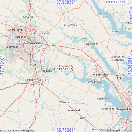
Charles City GPS coordinates[2]
37° 20' 36.528" North, 77° 4' 22.908" West
| Map corner | latitude | longitude |
|---|---|---|
| Upper-left | 37.90039°, | -77.77616° |
| Center: | 37.34348°, | -77.07303° |
| Lower-right: | 36.78241°, | -76.36991° |
| Map W x H: | 124.3×124.3 km | = 77.2×77.2mi |
| max Lat: | 71.29058° ⇑64.7% North |
| Charles City: | 37.34348° |
| min Lat: | ⇓35.3% South 19.06759° |
| min Long | Charles City | max Long |
| -171.73463° | -77.07303° | -66.98998° |
| W 80.2%⇐ | ⇒19.8% E |
Elevation
Elevation of Charles City is 13 m = 43 ft, and this is 281.8 m = 925 ft below average elevation for this country.
| Max E: |
3189 m = 10463 ft | 91.5% |
| Avg. | 294.8 m = 967 ft | |
| Charles City | 13 m = 43 ft | |
Min E: |
-60 m = -197 ft | 8.5% |
See also: United States elevation on elevation.city.
Geographical zone
Charles City is located in North temperate zone (between Tropic of Cancer and the Arctic Circle). Distance of this Northern Tropic circle is 1546.3 km =960.8 mi to South.| Distance of | km | miles | from Charles City |
|---|---|---|---|
| North Pole | 5854.9 | 3638.1 | to North |
| Arctic Circle | 3249 | 2018.8 | to North |
| Tropic Cancer | 1546.3 | 960.8 | to South |
| Equator | 4152.2 | 2580.1 | to South |


Nearby cities:
15 places around Charles City: (largest is in red/bold)
• Chester
32.6 km =20.3 mi,  272°
272°
• Colonial Heights
30.7 km =19.1 mi,  254°
254°
• Enon
22.1 km =13.7 mi, 266°
• Fort Lee
25.5 km =15.8 mi, 245°
• Fort Lee
28.7 km =17.8 mi,  306°
306°
• Highland Springs
31.8 km =19.8 mi,  315°
315°
• Hopewell
19.4 km =12.1 mi,  257°
257°
• New Kent
21.1 km =13.1 mi,  23°
23°
• Petersburg
31.8 km =19.8 mi, 246°
• Prince George
23.4 km =14.5 mi,  234°
234°
• Sandston
29.3 km =18.2 mi, 313°
• Surry
31.1 km =19.3 mi,  137°
137°
• West Point
32.2 km =20 mi,  49°
49°
• Williamsburg
30.3 km =18.8 mi,  104°
104°
• Williamsburg
33.3 km =20.7 mi, 104°
Sources, notices
• [Note1] Compared only with cities in United States existing in our database
• [Src1] Map data: © OpenStreetMap contributors (CC-BY-SA)
• [Src2] Other city data from geonames.org with taken over terms of usage.
• [Src3] Geographical zone / Annual Mean Temperature by Robert A. Rohde @ Wikipedia
