Grundy geodata
Grundy (Virginia) is a seat of a second-order administrative division; located in United States in America/New_York (GMT-4) time zone. With population of 978 people, there are 16430 cities with bigger population in this country. Compared to other cities in United States, 64.9% of cities are located further ↑North; 65.2% of cities are located further ←West and 77.1% of cities have lower elevation than Grundy. Note1


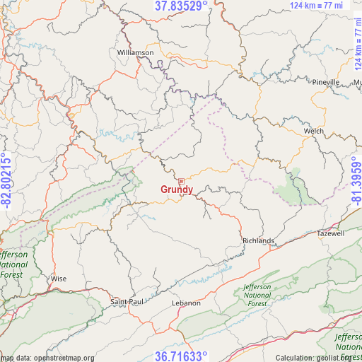
Grundy GPS coordinates[2]
37° 16' 40.404" North, 82° 5' 56.472" West
| Map corner | latitude | longitude |
|---|---|---|
| Upper-left | 37.83529°, | -82.80215° |
| Center: | 37.27789°, | -82.09902° |
| Lower-right: | 36.71633°, | -81.3959° |
| Map W x H: | 124.4×124.4 km | = 77.3×77.3mi |
| max Lat: | 71.29058° ⇑64.9% North |
| Grundy: | 37.27789° |
| min Lat: | ⇓35.1% South 19.06759° |
| min Long | Grundy | max Long |
| -171.73463° | -82.09902° | -66.98998° |
| W 65.2%⇐ | ⇒34.8% E |
Elevation
Elevation of Grundy is 328 m = 1076 ft, and this is 33.2 m = 109 ft above average elevation for this country.
| Max E: |
3189 m = 10463 ft | 22.9% |
| Grundy | 328 m 1076 ft | |
| Avg. | 294.8 m = 967 ft | |
Min E: |
-60 m = -197 ft | 77.1% |
See also: United States elevation on elevation.city.
Geographical zone
Grundy is located in North temperate zone (between Tropic of Cancer and the Arctic Circle). Distance of this Northern Tropic circle is 1539 km =956.3 mi to South.| Distance of | km | miles | from Grundy |
|---|---|---|---|
| North Pole | 5862.1 | 3642.5 | to North |
| Arctic Circle | 3256.3 | 2023.4 | to North |
| Tropic Cancer | 1539 | 956.3 | to South |
| Equator | 4144.9 | 2575.5 | to South |


Nearby cities:
15 places around Grundy: (largest is in red/bold)
• Cedar Bluff
36.8 km =22.9 mi,  125°
125°
• Claypool Hill
39 km =24.2 mi, 127°
• Clintwood
34.7 km =21.6 mi,  245°
245°
• Dante
37.7 km =23.4 mi,  207°
207°
• Elkhorn City
22.5 km =14 mi,  277°
277°
• Gilbert Creek
37.7 km =23.4 mi,  28°
28°
• Honaker
31.1 km =19.3 mi,  159°
159°
• Lebanon
41.9 km =26 mi,  177°
177°
• Phelps
26.5 km =16.5 mi,  350°
350°
• Pikeville
43.3 km =26.9 mi,  301°
301°
• Raven
30.3 km =18.8 mi, 134°
• Red Jacket
41.4 km =25.7 mi, 354°
• Richlands
34 km =21.1 mi, 127°
• Saint Paul
45.5 km =28.3 mi,  204°
204°
• War
36.2 km =22.5 mi,  85°
85°
Sources, notices
• [Note1] Compared only with cities in United States existing in our database
• [Src1] Map data: © OpenStreetMap contributors (CC-BY-SA)
• [Src2] Other city data from geonames.org with taken over terms of usage.
• [Src3] Geographical zone / Annual Mean Temperature by Robert A. Rohde @ Wikipedia
