Eastville geodata
Eastville (Virginia) is a seat of a second-order administrative division; located in United States in America/New_York (GMT-4) time zone. With population of 167 people, there are 21020 cities with bigger population in this country. Compared to other cities in United States, 64.6% of cities are located further ↑North; 84.2% of cities are located further ←West and 97.4% of cities have higher elevation than Eastville. Note1


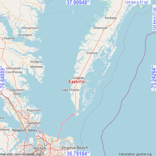
Eastville GPS coordinates[2]
37° 21' 9.504" North, 75° 56' 44.736" West
| Map corner | latitude | longitude |
|---|---|---|
| Upper-left | 37.90948°, | -76.64889° |
| Center: | 37.35264°, | -75.94576° |
| Lower-right: | 36.79164°, | -75.24264° |
| Map W x H: | 124.3×124.3 km | = 77.2×77.2mi |
| max Lat: | 71.29058° ⇑64.6% North |
| Eastville: | 37.35264° |
| min Lat: | ⇓35.4% South 19.06759° |
| min Long | Eastville | max Long |
| -171.73463° | -75.94576° | -66.98998° |
| W 84.2%⇐ | ⇒15.8% E |
Elevation
Elevation of Eastville is 6 m = 20 ft, and this is 288.8 m = 948 ft below average elevation for this country.
| Max E: |
3189 m = 10463 ft | 97.4% |
| Avg. | 294.8 m = 967 ft | |
| Eastville | 6 m = 20 ft | |
Min E: |
-60 m = -197 ft | 2.6% |
See also: United States elevation on elevation.city.
Geographical zone
Eastville is located in North temperate zone (between Tropic of Cancer and the Arctic Circle). Distance of this Northern Tropic circle is 1547.3 km =961.4 mi to South.| Distance of | km | miles | from Eastville |
|---|---|---|---|
| North Pole | 5853.8 | 3637.4 | to North |
| Arctic Circle | 3247.9 | 2018.2 | to North |
| Tropic Cancer | 1547.3 | 961.4 | to South |
| Equator | 4153.2 | 2580.7 | to South |


Nearby cities:
15 places around Eastville: (largest is in red/bold)
• Accomac
47.7 km =29.6 mi,  31°
31°
• Belle Haven
25 km =15.5 mi, 26°
• Boston
30 km =18.6 mi,  17°
17°
• Cape Charles
11.1 km =6.9 mi,  214°
214°
• Deltaville
41.2 km =25.6 mi,  303°
303°
• East Hampton
49 km =30.4 mi,  224°
224°
• Exmore
22.7 km =14.1 mi, 28°
• Gloucester Point
50 km =31.1 mi,  257°
257°
• Gwynn
34.6 km =21.5 mi, 299°
• Hampton
50.4 km =31.3 mi, 224°
• Mathews
34.4 km =21.4 mi,  285°
285°
• Onancock
43.5 km =27 mi, 23°
• Onley
42.7 km =26.5 mi, 28°
• Poquoson
43.7 km =27.2 mi,  234°
234°
• Yorktown
51.5 km =32 mi, 255°
Sources, notices
• [Note1] Compared only with cities in United States existing in our database
• [Src1] Map data: © OpenStreetMap contributors (CC-BY-SA)
• [Src2] Other city data from geonames.org with taken over terms of usage.
• [Src3] Geographical zone / Annual Mean Temperature by Robert A. Rohde @ Wikipedia
