Gwynn geodata
Gwynn (Virginia) is a populated place; located in United States in America/New_York (GMT-4) time zone. With population of 602 people, there are 19678 cities with bigger population in this country. Compared to other cities in United States, 64% of cities are located further ↑North; 83.2% of cities are located further ←West and 97.4% of cities have higher elevation than Gwynn. Note1


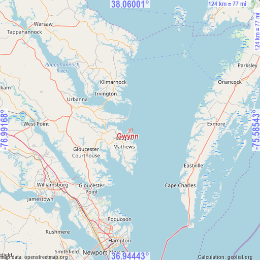
Gwynn GPS coordinates[2]
37° 30' 15.48" North, 76° 17' 18.78" West
| Map corner | latitude | longitude |
|---|---|---|
| Upper-left | 38.06001°, | -76.99168° |
| Center: | 37.5043°, | -76.28855° |
| Lower-right: | 36.94443°, | -75.58543° |
| Map W x H: | 124×124 km | = 77.1×77.1mi |
| max Lat: | 71.29058° ⇑64% North |
| Gwynn: | 37.5043° |
| min Lat: | ⇓36% South 19.06759° |
| min Long | Gwynn | max Long |
| -171.73463° | -76.28855° | -66.98998° |
| W 83.2%⇐ | ⇒16.8% E |
Elevation
Elevation of Gwynn is 6 m = 20 ft, and this is 288.8 m = 948 ft below average elevation for this country.
| Max E: |
3189 m = 10463 ft | 97.4% |
| Avg. | 294.8 m = 967 ft | |
| Gwynn | 6 m = 20 ft | |
Min E: |
-60 m = -197 ft | 2.6% |
See also: United States elevation on elevation.city.
Geographical zone
Gwynn is located in North temperate zone (between Tropic of Cancer and the Arctic Circle). Distance of this Northern Tropic circle is 1564.2 km =971.9 mi to South.| Distance of | km | miles | from Gwynn |
|---|---|---|---|
| North Pole | 5837 | 3626.9 | to North |
| Arctic Circle | 3231.1 | 2007.7 | to North |
| Tropic Cancer | 1564.2 | 971.9 | to South |
| Equator | 4170.1 | 2591.2 | to South |


Nearby cities:
15 places around Gwynn: (largest is in red/bold)
• Belle Haven
41.6 km =25.8 mi,  82°
82°
• Boston
41 km =25.5 mi,  73°
73°
• Cape Charles
35.4 km =22 mi,  137°
137°
• Deltaville
7.1 km =4.4 mi,  322°
322°
• Eastville
34.6 km =21.5 mi,  119°
119°
• Exmore
41.2 km =25.6 mi,  85°
85°
• Gloucester Courthouse
23.5 km =14.6 mi,  243°
243°
• Gloucester Point
33.4 km =20.8 mi,  213°
213°
• Kilmarnock
24.3 km =15.1 mi,  340°
340°
• Lancaster
33.4 km =20.8 mi,  332°
332°
• Mathews
8 km =5 mi,  200°
200°
• Poquoson
42.8 km =26.6 mi,  186°
186°
• Saluda
29.3 km =18.2 mi,  292°
292°
• Tangier
44.3 km =27.5 mi,  36°
36°
• Yorktown
35.4 km =22 mi, 213°
Sources, notices
• [Note1] Compared only with cities in United States existing in our database
• [Src1] Map data: © OpenStreetMap contributors (CC-BY-SA)
• [Src2] Other city data from geonames.org with taken over terms of usage.
• [Src3] Geographical zone / Annual Mean Temperature by Robert A. Rohde @ Wikipedia
