Fort Chiswell geodata
Fort Chiswell (Virginia) is a populated place; located in United States in America/New_York (GMT-4) time zone. With population of 939 people, there are 16722 cities with bigger population in this country. Compared to other cities in United States, 66.4% of cities are located further ↑North; 69.6% of cities are located further ←West and 90% of cities have lower elevation than Fort Chiswell. Note1


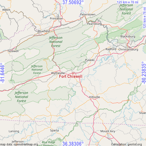
Fort Chiswell GPS coordinates[2]
36° 56' 49.416" North, 80° 56' 29.292" West
| Map corner | latitude | longitude |
|---|---|---|
| Upper-left | 37.50692°, | -81.6446° |
| Center: | 36.94706°, | -80.94147° |
| Lower-right: | 36.38306°, | -80.23835° |
| Map W x H: | 125×125 km | = 77.7×77.7mi |
| max Lat: | 71.29058° ⇑66.4% North |
| Fort Chiswell: | 36.94706° |
| min Lat: | ⇓33.6% South 19.06759° |
| min Long | Fort Chiswell | max Long |
| -171.73463° | -80.94147° | -66.98998° |
| W 69.6%⇐ | ⇒30.4% E |
Elevation
Elevation of Fort Chiswell is 622 m = 2041 ft, and this is 327.2 m = 1073 ft above average elevation for this country.
| Max E: |
3189 m = 10463 ft | 10% |
| Fort Chiswell | 622 m 2041 ft | |
| Avg. | 294.8 m = 967 ft | |
Min E: |
-60 m = -197 ft | 90% |
See also: United States elevation on elevation.city.
Geographical zone
Fort Chiswell is located in North temperate zone (between Tropic of Cancer and the Arctic Circle). Distance of this Northern Tropic circle is 1502.2 km =933.4 mi to South.| Distance of | km | miles | from Fort Chiswell |
|---|---|---|---|
| North Pole | 5898.9 | 3665.4 | to North |
| Arctic Circle | 3293 | 2046.2 | to North |
| Tropic Cancer | 1502.2 | 933.4 | to South |
| Equator | 4108.1 | 2552.7 | to South |


Nearby cities:
15 places around Fort Chiswell: (largest is in red/bold)
• Atkins
43.8 km =27.2 mi,  258°
258°
• Bland
23.2 km =14.4 mi,  318°
318°
• Bluefield
43.7 km =27.2 mi,  325°
325°
• Dublin
28.8 km =17.9 mi,  52°
52°
• Fairlawn
39.2 km =24.4 mi,  55°
55°
• Galax
31.8 km =19.8 mi,  177°
177°
• Hillsville
27.5 km =17.1 mi,  138°
138°
• Independence
40.7 km =25.3 mi,  207°
207°
• Ivanhoe
12.1 km =7.5 mi,  190°
190°
• Max Meadows
2.7 km =1.7 mi,  344°
344°
• Pulaski
18.2 km =11.3 mi, 52°
• Radford
38.4 km =23.9 mi, 57°
• Rural Retreat
30.3 km =18.8 mi, 258°
• Woodlawn
27.1 km =16.8 mi,  157°
157°
• Wytheville
12.7 km =7.9 mi,  270°
270°
Sources, notices
• [Note1] Compared only with cities in United States existing in our database
• [Src1] Map data: © OpenStreetMap contributors (CC-BY-SA)
• [Src2] Other city data from geonames.org with taken over terms of usage.
• [Src3] Geographical zone / Annual Mean Temperature by Robert A. Rohde @ Wikipedia
