Independence geodata
Independence (Virginia) is a seat of a second-order administrative division; located in United States in America/New_York (GMT-4) time zone. With population of 927 people, there are 16817 cities with bigger population in this country. Compared to other cities in United States, 67.6% of cities are located further ↑North; 69% of cities are located further ←West and 92.2% of cities have lower elevation than Independence. Note1


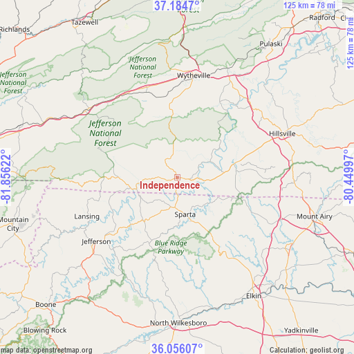
Independence GPS coordinates[2]
36° 37' 20.82" North, 81° 9' 11.124" West
| Map corner | latitude | longitude |
|---|---|---|
| Upper-left | 37.1847°, | -81.85622° |
| Center: | 36.62245°, | -81.15309° |
| Lower-right: | 36.05607°, | -80.44997° |
| Map W x H: | 125.5×125.5 km | = 78×78mi |
| max Lat: | 71.29058° ⇑67.6% North |
| Independence: | 36.62245° |
| min Lat: | ⇓32.4% South 19.06759° |
| min Long | Independence | max Long |
| -171.73463° | -81.15309° | -66.98998° |
| W 69%⇐ | ⇒31% E |
Elevation
Elevation of Independence is 825 m = 2707 ft, and this is 530.2 m = 1740 ft above average elevation for this country.
| Max E: |
3189 m = 10463 ft | 7.8% |
| Independence | 825 m 2707 ft | |
| Avg. | 294.8 m = 967 ft | |
Min E: |
-60 m = -197 ft | 92.2% |
See also: United States elevation on elevation.city.
Geographical zone
Independence is located in North temperate zone (between Tropic of Cancer and the Arctic Circle). Distance of this Northern Tropic circle is 1466.1 km =911 mi to South.| Distance of | km | miles | from Independence |
|---|---|---|---|
| North Pole | 5935 | 3687.8 | to North |
| Arctic Circle | 3329.1 | 2068.6 | to North |
| Tropic Cancer | 1466.1 | 911 | to South |
| Equator | 4072 | 2530.2 | to South |


Nearby cities:
15 places around Independence: (largest is in red/bold)
• Atkins
36.4 km =22.6 mi,  318°
318°
• Fort Chiswell
40.7 km =25.3 mi,  27°
27°
• Galax
20.9 km =13 mi,  78°
78°
• Hays
41.6 km =25.8 mi,  175°
175°
• Hillsville
40.4 km =25.1 mi,  67°
67°
• Ivanhoe
29.4 km =18.3 mi, 34°
• Jefferson
36.4 km =22.6 mi,  231°
231°
• Marion
40 km =24.9 mi,  306°
306°
• Rural Retreat
32.1 km =19.9 mi,  340°
340°
• Sparta
13.3 km =8.3 mi,  167°
167°
• Sugar Grove
28.7 km =17.8 mi, 306°
• Thurmond
34.8 km =21.6 mi,  144°
144°
• West Jefferson
38.9 km =24.2 mi, 231°
• Woodlawn
31.5 km =19.6 mi, 69°
• Wytheville
36.8 km =22.9 mi,  9°
9°
Sources, notices
• [Note1] Compared only with cities in United States existing in our database
• [Src1] Map data: © OpenStreetMap contributors (CC-BY-SA)
• [Src2] Other city data from geonames.org with taken over terms of usage.
• [Src3] Geographical zone / Annual Mean Temperature by Robert A. Rohde @ Wikipedia
