Woodlawn geodata
Woodlawn (Virginia) is a populated place; located in United States in America/New_York (GMT-4) time zone. With population of 2,343 people, there are 10984 cities with bigger population in this country. Compared to other cities in United States, 67.2% of cities are located further ↑North; 69.9% of cities are located further ←West and 91.7% of cities have lower elevation than Woodlawn. Note1


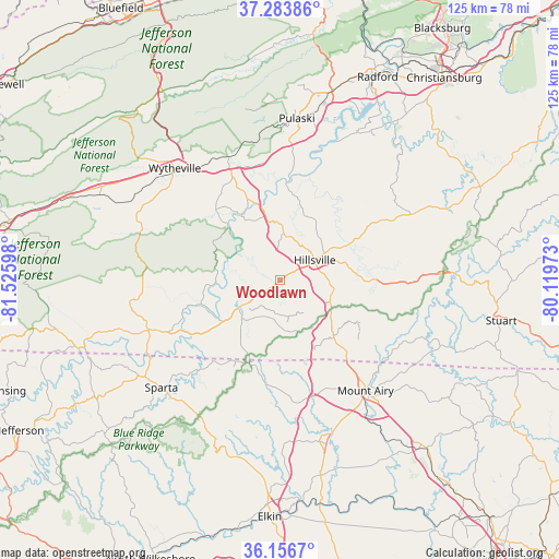
Woodlawn GPS coordinates[2]
36° 43' 20.46" North, 80° 49' 22.26" West
| Map corner | latitude | longitude |
|---|---|---|
| Upper-left | 37.28386°, | -81.52598° |
| Center: | 36.72235°, | -80.82285° |
| Lower-right: | 36.1567°, | -80.11973° |
| Map W x H: | 125.3×125.3 km | = 77.9×77.9mi |
| max Lat: | 71.29058° ⇑67.2% North |
| Woodlawn: | 36.72235° |
| min Lat: | ⇓32.8% South 19.06759° |
| min Long | Woodlawn | max Long |
| -171.73463° | -80.82285° | -66.98998° |
| W 69.9%⇐ | ⇒30.1% E |
Elevation
Elevation of Woodlawn is 768 m = 2520 ft, and this is 473.2 m = 1552 ft above average elevation for this country.
| Max E: |
3189 m = 10463 ft | 8.3% |
| Woodlawn | 768 m 2520 ft | |
| Avg. | 294.8 m = 967 ft | |
Min E: |
-60 m = -197 ft | 91.7% |
See also: United States elevation on elevation.city.
Geographical zone
Woodlawn is located in North temperate zone (between Tropic of Cancer and the Arctic Circle). Distance of this Northern Tropic circle is 1477.2 km =917.9 mi to South.| Distance of | km | miles | from Woodlawn |
|---|---|---|---|
| North Pole | 5923.9 | 3680.9 | to North |
| Arctic Circle | 3318 | 2061.7 | to North |
| Tropic Cancer | 1477.2 | 917.9 | to South |
| Equator | 4083.1 | 2537.1 | to South |


Nearby cities:
15 places around Woodlawn: (largest is in red/bold)
• Cana
20 km =12.4 mi,  137°
137°
• Dobson
37.4 km =23.2 mi,  166°
166°
• Flat Rock
32.5 km =20.2 mi, 135°
• Fort Chiswell
27.1 km =16.8 mi,  337°
337°
• Galax
11.3 km =7 mi,  232°
232°
• Hillsville
9 km =5.6 mi,  60°
60°
• Independence
31.5 km =19.6 mi,  249°
249°
• Ivanhoe
18.3 km =11.4 mi,  315°
315°
• Max Meadows
29.8 km =18.5 mi, 337°
• Mount Airy
31.4 km =19.5 mi, 142°
• Pulaski
36.4 km =22.6 mi,  6°
6°
• Sparta
35.9 km =22.3 mi, 227°
• Toast
30.3 km =18.8 mi, 144°
• White Plains
35.1 km =21.8 mi,  151°
151°
• Wytheville
34.3 km =21.3 mi, 317°
Sources, notices
• [Note1] Compared only with cities in United States existing in our database
• [Src1] Map data: © OpenStreetMap contributors (CC-BY-SA)
• [Src2] Other city data from geonames.org with taken over terms of usage.
• [Src3] Geographical zone / Annual Mean Temperature by Robert A. Rohde @ Wikipedia
