Hillsville geodata
Hillsville (Virginia) is a seat of a second-order administrative division; located in United States in America/New_York (GMT-4) time zone. With population of 2,677 people, there are 10224 cities with bigger population in this country. Compared to other cities in United States, 67% of cities are located further ↑North; 70.1% of cities are located further ←West and 91.6% of cities have lower elevation than Hillsville. Note1


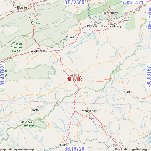
Hillsville GPS coordinates[2]
36° 45' 45.468" North, 80° 44' 5.244" West
| Map corner | latitude | longitude |
|---|---|---|
| Upper-left | 37.32385°, | -81.43792° |
| Center: | 36.76263°, | -80.73479° |
| Lower-right: | 36.19728°, | -80.03167° |
| Map W x H: | 125.3×125.3 km | = 77.9×77.9mi |
| max Lat: | 71.29058° ⇑67% North |
| Hillsville: | 36.76263° |
| min Lat: | ⇓33% South 19.06759° |
| min Long | Hillsville | max Long |
| -171.73463° | -80.73479° | -66.98998° |
| W 70.1%⇐ | ⇒29.9% E |
Elevation
Elevation of Hillsville is 764 m = 2507 ft, and this is 469.2 m = 1539 ft above average elevation for this country.
| Max E: |
3189 m = 10463 ft | 8.4% |
| Hillsville | 764 m 2507 ft | |
| Avg. | 294.8 m = 967 ft | |
Min E: |
-60 m = -197 ft | 91.6% |
See also: United States elevation on elevation.city.
Geographical zone
Hillsville is located in North temperate zone (between Tropic of Cancer and the Arctic Circle). Distance of this Northern Tropic circle is 1481.7 km =920.7 mi to South.| Distance of | km | miles | from Hillsville |
|---|---|---|---|
| North Pole | 5919.4 | 3678.1 | to North |
| Arctic Circle | 3313.6 | 2059 | to North |
| Tropic Cancer | 1481.7 | 920.7 | to South |
| Equator | 4087.6 | 2539.9 | to South |


Nearby cities:
15 places around Hillsville: (largest is in red/bold)
• Cana
20 km =12.4 mi,  163°
163°
• Dublin
38.4 km =23.9 mi,  6°
6°
• Flat Rock
31.5 km =19.6 mi,  152°
152°
• Floyd
40.4 km =25.1 mi,  65°
65°
• Fort Chiswell
27.5 km =17.1 mi,  318°
318°
• Galax
20.3 km =12.6 mi,  236°
236°
• Independence
40.4 km =25.1 mi,  247°
247°
• Ivanhoe
22.4 km =13.9 mi,  292°
292°
• Max Meadows
30 km =18.6 mi, 320°
• Mount Airy
31.4 km =19.5 mi, 158°
• Pulaski
32 km =19.9 mi,  352°
352°
• Toast
30.7 km =19.1 mi, 161°
• White Plains
36.4 km =22.6 mi,  165°
165°
• Woodlawn
9 km =5.6 mi, 240°
• Wytheville
37.4 km =23.2 mi,  303°
303°
Sources, notices
• [Note1] Compared only with cities in United States existing in our database
• [Src1] Map data: © OpenStreetMap contributors (CC-BY-SA)
• [Src2] Other city data from geonames.org with taken over terms of usage.
• [Src3] Geographical zone / Annual Mean Temperature by Robert A. Rohde @ Wikipedia
