Front Royal geodata
Front Royal (Virginia) is a seat of a second-order administrative division; located in United States in America/New_York (GMT-4) time zone. With population of 15,070 people, there are 3234 cities with bigger population in this country. Compared to other cities in United States, 55.7% of cities are located further ↑North; 77.4% of cities are located further ←West and 56.8% of cities have higher elevation than Front Royal. Note1


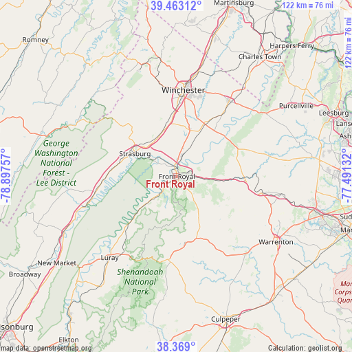
Front Royal GPS coordinates[2]
38° 55' 5.412" North, 78° 11' 39.984" West
| Map corner | latitude | longitude |
|---|---|---|
| Upper-left | 39.46312°, | -78.89757° |
| Center: | 38.91817°, | -78.19444° |
| Lower-right: | 38.369°, | -77.49132° |
| Map W x H: | 121.7×121.7 km | = 75.6×75.6mi |
| max Lat: | 71.29058° ⇑55.7% North |
| Front Royal: | 38.91817° |
| min Lat: | ⇓44.3% South 19.06759° |
| min Long | Front Royal | max Long |
| -171.73463° | -78.19444° | -66.98998° |
| W 77.4%⇐ | ⇒22.6% E |
Elevation
Elevation of Front Royal is 172 m = 564 ft, and this is 122.8 m = 403 ft below average elevation for this country.
| Max E: |
3189 m = 10463 ft | 56.8% |
| Avg. | 294.8 m = 967 ft | |
| Front Royal | 172 m = 564 ft | |
Min E: |
-60 m = -197 ft | 43.2% |
See also: United States elevation on elevation.city.
Geographical zone
Front Royal is located in North temperate zone (between Tropic of Cancer and the Arctic Circle). Distance of this Northern Tropic circle is 1721.4 km =1069.6 mi to South.| Distance of | km | miles | from Front Royal |
|---|---|---|---|
| North Pole | 5679.8 | 3529.3 | to North |
| Arctic Circle | 3073.9 | 1910 | to North |
| Tropic Cancer | 1721.4 | 1069.6 | to South |
| Equator | 4327.3 | 2688.9 | to South |


Nearby cities:
15 places around Front Royal: (largest is in red/bold)
• Apple Mountain Lake
8.1 km =5 mi,  85°
85°
• Berryville
31.8 km =19.8 mi,  35°
35°
• Boyce
22.7 km =14.1 mi,  30°
30°
• Chester Gap
8.8 km =5.5 mi,  144°
144°
• Marshall
29.7 km =18.5 mi,  101°
101°
• Maurertown
23.3 km =14.5 mi,  273°
273°
• Middletown
14.3 km =8.9 mi,  328°
328°
• Shenandoah Farms
12.5 km =7.8 mi,  55°
55°
• Shenandoah Shores
6.5 km =4 mi, 43°
• Skyland Estates
9.7 km =6 mi, 86°
• Stephens City
18.5 km =11.5 mi,  353°
353°
• Strasburg
16.2 km =10.1 mi,  298°
298°
• Washington
23 km =14.3 mi,  172°
172°
• Winchester
29.9 km =18.6 mi,  5°
5°
• Woodstock
27.2 km =16.9 mi,  261°
261°
Sources, notices
• [Note1] Compared only with cities in United States existing in our database
• [Src1] Map data: © OpenStreetMap contributors (CC-BY-SA)
• [Src2] Other city data from geonames.org with taken over terms of usage.
• [Src3] Geographical zone / Annual Mean Temperature by Robert A. Rohde @ Wikipedia
