Washington geodata
Washington (Virginia) is a seat of a second-order administrative division; located in United States in America/New_York (GMT-4) time zone. With population of 128 people, there are 21031 cities with bigger population in this country. Compared to other cities in United States, 57.3% of cities are located further ↑North; 77.5% of cities are located further ←West and 52.8% of cities have lower elevation than Washington. Note1


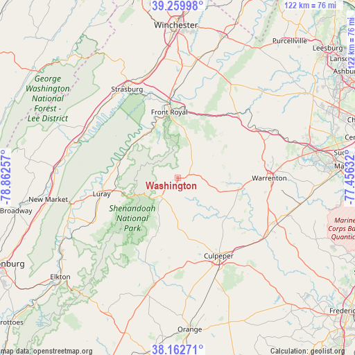
Washington GPS coordinates[2]
38° 42' 48.42" North, 78° 9' 33.984" West
| Map corner | latitude | longitude |
|---|---|---|
| Upper-left | 39.25998°, | -78.86257° |
| Center: | 38.71345°, | -78.15944° |
| Lower-right: | 38.16271°, | -77.45632° |
| Map W x H: | 122×122 km | = 75.8×75.8mi |
| max Lat: | 71.29058° ⇑57.3% North |
| Washington: | 38.71345° |
| min Lat: | ⇓42.7% South 19.06759° |
| min Long | Washington | max Long |
| -171.73463° | -78.15944° | -66.98998° |
| W 77.5%⇐ | ⇒22.5% E |
Elevation
Elevation of Washington is 209 m = 686 ft, and this is 85.8 m = 281 ft below average elevation for this country.
| Max E: |
3189 m = 10463 ft | 47.2% |
| Avg. | 294.8 m = 967 ft | |
| Washington | 209 m = 686 ft | |
Min E: |
-60 m = -197 ft | 52.8% |
See also: United States elevation on elevation.city.
Geographical zone
Washington is located in North temperate zone (between Tropic of Cancer and the Arctic Circle). Distance of this Northern Tropic circle is 1698.6 km =1055.5 mi to South.| Distance of | km | miles | from Washington |
|---|---|---|---|
| North Pole | 5702.5 | 3543.4 | to North |
| Arctic Circle | 3096.6 | 1924.1 | to North |
| Tropic Cancer | 1698.6 | 1055.5 | to South |
| Equator | 4304.5 | 2674.7 | to South |


Nearby cities:
15 places around Washington: (largest is in red/bold)
• Apple Mountain Lake
24 km =14.9 mi,  12°
12°
• Brightwood
32.6 km =20.3 mi,  185°
185°
• Chester Gap
15.7 km =9.8 mi, 7°
• Culpeper
30.2 km =18.8 mi,  152°
152°
• Front Royal
23 km =14.3 mi,  352°
352°
• Luray
26.6 km =16.5 mi,  258°
258°
• Marshall
31.1 km =19.3 mi,  57°
57°
• Merrimac
29.8 km =18.5 mi,  166°
166°
• Opal
32.9 km =20.4 mi,  108°
108°
• Round Hill
17.1 km =10.6 mi,  179°
179°
• Shenandoah Farms
30.7 km =19.1 mi, 13°
• Shenandoah Shores
27.5 km =17.1 mi,  2°
2°
• Skyland Estates
24.3 km =15.1 mi,  16°
16°
• Stanley
33.5 km =20.8 mi,  242°
242°
• Warrenton
31.6 km =19.6 mi,  90°
90°
Sources, notices
• [Note1] Compared only with cities in United States existing in our database
• [Src1] Map data: © OpenStreetMap contributors (CC-BY-SA)
• [Src2] Other city data from geonames.org with taken over terms of usage.
• [Src3] Geographical zone / Annual Mean Temperature by Robert A. Rohde @ Wikipedia
