Shenandoah Farms geodata
Shenandoah Farms (Virginia) is a populated place; located in United States in America/New_York (GMT-4) time zone. With population of 3,033 people, there are 9574 cities with bigger population in this country. Compared to other cities in United States, 55.1% of cities are located further ↑North; 77.7% of cities are located further ←West and 56.2% of cities have higher elevation than Shenandoah Farms. Note1


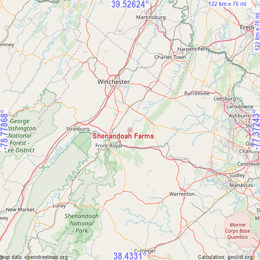
Shenandoah Farms GPS coordinates[2]
38° 58' 54.408" North, 78° 4' 31.98" West
| Map corner | latitude | longitude |
|---|---|---|
| Upper-left | 39.52624°, | -78.77868° |
| Center: | 38.98178°, | -78.07555° |
| Lower-right: | 38.4331°, | -77.37243° |
| Map W x H: | 121.5×121.5 km | = 75.5×75.5mi |
| max Lat: | 71.29058° ⇑55.1% North |
| Shenandoah Farms: | 38.98178° |
| min Lat: | ⇓44.9% South 19.06759° |
| min Long | Shenandoah Farm | max Long |
| -171.73463° | -78.07555° | -66.98998° |
| W 77.7%⇐ | ⇒22.3% E |
Elevation
Elevation of Shenandoah Farms is 175 m = 574 ft, and this is 119.8 m = 393 ft below average elevation for this country.
| Max E: |
3189 m = 10463 ft | 56.2% |
| Avg. | 294.8 m = 967 ft | |
| Shenandoah Farms | 175 m = 574 ft | |
Min E: |
-60 m = -197 ft | 43.8% |
See also: United States elevation on elevation.city.
Geographical zone
Shenandoah Farms is located in North temperate zone (between Tropic of Cancer and the Arctic Circle). Distance of this Northern Tropic circle is 1728.4 km =1074 mi to South.| Distance of | km | miles | from Shenandoah Farms |
|---|---|---|---|
| North Pole | 5672.7 | 3524.9 | to North |
| Arctic Circle | 3066.8 | 1905.6 | to North |
| Tropic Cancer | 1728.4 | 1074 | to South |
| Equator | 4334.4 | 2693.3 | to South |


Nearby cities:
15 places around Shenandoah Farms: (largest is in red/bold)
• Apple Mountain Lake
6.8 km =4.2 mi,  199°
199°
• Berryville
20.5 km =12.7 mi,  23°
23°
• Boyce
12.5 km =7.8 mi,  6°
6°
• Chester Gap
15.2 km =9.4 mi, 199°
• Front Royal
12.5 km =7.8 mi,  235°
235°
• Marshall
22.9 km =14.2 mi,  124°
124°
• Middleburg
29.4 km =18.3 mi,  92°
92°
• Middletown
18.4 km =11.4 mi,  286°
286°
• Shenandoah Retreat
24.9 km =15.5 mi,  46°
46°
• Shenandoah Shores
6.3 km =3.9 mi,  247°
247°
• Skyland Estates
6.5 km =4 mi,  185°
185°
• Stephens City
16.7 km =10.4 mi,  312°
312°
• Strasburg
24.5 km =15.2 mi,  271°
271°
• Washington
30.7 km =19.1 mi, 193°
• Winchester
23.9 km =14.9 mi,  341°
341°
Sources, notices
• [Note1] Compared only with cities in United States existing in our database
• [Src1] Map data: © OpenStreetMap contributors (CC-BY-SA)
• [Src2] Other city data from geonames.org with taken over terms of usage.
• [Src3] Geographical zone / Annual Mean Temperature by Robert A. Rohde @ Wikipedia
