Portsmouth Heights geodata
Portsmouth Heights (Virginia) is a populated place; located in United States in America/New_York (GMT-4) time zone. With population of 99,049 people, there are 354 cities with bigger population in this country. Compared to other cities in United States, 66.8% of cities are located further ↑North; 83% of cities are located further ←West and 96.6% of cities have higher elevation than Portsmouth Heights. Note1


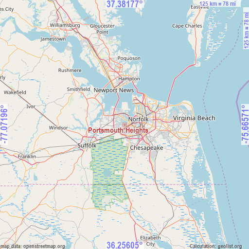
Portsmouth Heights GPS coordinates[2]
36° 49' 15.528" North, 76° 22' 7.788" West
| Map corner | latitude | longitude |
|---|---|---|
| Upper-left | 37.38177°, | -77.07196° |
| Center: | 36.82098°, | -76.36883° |
| Lower-right: | 36.25605°, | -75.66571° |
| Map W x H: | 125.2×125.2 km | = 77.8×77.8mi |
| max Lat: | 71.29058° ⇑66.8% North |
| Portsmouth Heights: | 36.82098° |
| min Lat: | ⇓33.2% South 19.06759° |
| min Long | Portsmouth Heig | max Long |
| -171.73463° | -76.36883° | -66.98998° |
| W 83%⇐ | ⇒17% E |
Elevation
Elevation of Portsmouth Heights is 7 m = 23 ft, and this is 287.8 m = 944 ft below average elevation for this country.
| Max E: |
3189 m = 10463 ft | 96.6% |
| Avg. | 294.8 m = 967 ft | |
| Portsmouth Heights | 7 m = 23 ft | |
Min E: |
-60 m = -197 ft | 3.4% |
See also: Portsmouth Heights elevation on elevation.city.
Geographical zone
Portsmouth Heights is located in North temperate zone (between Tropic of Cancer and the Arctic Circle). Distance of this Northern Tropic circle is 1488.2 km =924.7 mi to South.| Distance of | km | miles | from Portsmouth Heights |
|---|---|---|---|
| North Pole | 5913 | 3674.2 | to North |
| Arctic Circle | 3307.1 | 2054.9 | to North |
| Tropic Cancer | 1488.2 | 924.7 | to South |
| Equator | 4094.1 | 2544 | to South |


Nearby cities:
15 places around Portsmouth Heights: (largest is in red/bold)
• Benns Church
23.3 km =14.5 mi,  303°
303°
• Carrollton
22.1 km =13.7 mi,  309°
309°
• Chesapeake
8.4 km =5.2 mi,  91°
91°
• East Hampton
24.3 km =15.1 mi,  7°
7°
• Hampton
23.3 km =14.5 mi, 5°
• Isle of Wight
31.7 km =19.7 mi,  287°
287°
• Newport News
30.5 km =19 mi,  342°
342°
• Norfolk
8 km =5 mi,  68°
68°
• Poquoson
33.6 km =20.9 mi,  3°
3°
• Portsmouth
6.5 km =4 mi,  75°
75°
• Smithfield
29.4 km =18.3 mi, 307°
• South Suffolk
22.9 km =14.2 mi,  239°
239°
• Suffolk
21.8 km =13.5 mi, 241°
• Virginia Beach
35 km =21.7 mi, 84°
• Windsor
33.4 km =20.8 mi,  267°
267°
Sources, notices
• [Note1] Compared only with cities in United States existing in our database
• [Src1] Map data: © OpenStreetMap contributors (CC-BY-SA)
• [Src2] Other city data from geonames.org with taken over terms of usage.
• [Src3] Geographical zone / Annual Mean Temperature by Robert A. Rohde @ Wikipedia
