Suffolk geodata
Suffolk (Virginia) is a seat of a second-order administrative division; located in United States in America/New_York (GMT-4) time zone. With population of 88,161 people, there are 422 cities with bigger population in this country. Compared to other cities in United States, 67.2% of cities are located further ↑North; 82.3% of cities are located further ←West and 87.4% of cities have higher elevation than Suffolk. Note1


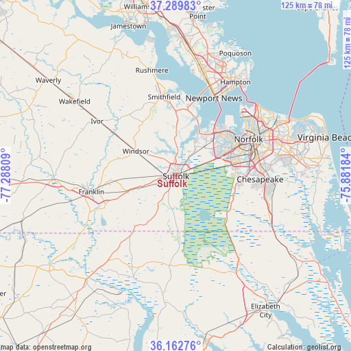
Suffolk GPS coordinates[2]
36° 43' 42.096" North, 76° 35' 5.856" West
| Map corner | latitude | longitude |
|---|---|---|
| Upper-left | 37.28983°, | -77.28809° |
| Center: | 36.72836°, | -76.58496° |
| Lower-right: | 36.16276°, | -75.88184° |
| Map W x H: | 125.3×125.3 km | = 77.9×77.9mi |
| max Lat: | 71.29058° ⇑67.2% North |
| Suffolk: | 36.72836° |
| min Lat: | ⇓32.8% South 19.06759° |
| min Long | Suffolk | max Long |
| -171.73463° | -76.58496° | -66.98998° |
| W 82.3%⇐ | ⇒17.7% E |
Elevation
Elevation of Suffolk is 22 m = 72 ft, and this is 272.8 m = 895 ft below average elevation for this country.
| Max E: |
3189 m = 10463 ft | 87.4% |
| Avg. | 294.8 m = 967 ft | |
| Suffolk | 22 m = 72 ft | |
Min E: |
-60 m = -197 ft | 12.6% |
See also: Suffolk elevation on elevation.city.
Geographical zone
Suffolk is located in North temperate zone (between Tropic of Cancer and the Arctic Circle). Distance of this Northern Tropic circle is 1477.9 km =918.3 mi to South.| Distance of | km | miles | from Suffolk |
|---|---|---|---|
| North Pole | 5923.3 | 3680.6 | to North |
| Arctic Circle | 3317.4 | 2061.3 | to North |
| Tropic Cancer | 1477.9 | 918.3 | to South |
| Equator | 4083.8 | 2537.6 | to South |


Nearby cities:
15 places around Suffolk: (largest is in red/bold)
• Benns Church
23.3 km =14.5 mi,  359°
359°
• Carrollton
24.4 km =15.2 mi,  5°
5°
• Chesapeake
29.4 km =18.3 mi,  69°
69°
• Franklin
30.6 km =19 mi,  259°
259°
• Gatesville
39.1 km =24.3 mi,  202°
202°
• Hampton
39.7 km =24.7 mi,  32°
32°
• Isle of Wight
22.7 km =14.1 mi,  331°
331°
• Newport News
40.8 km =25.4 mi, 14°
• Norfolk
29.8 km =18.5 mi,  63°
63°
• Portsmouth
28.2 km =17.5 mi, 65°
• Portsmouth Heights
21.8 km =13.5 mi, 61°
• Rushmere
38.5 km =23.9 mi,  347°
347°
• Smithfield
28.5 km =17.7 mi, 351°
• South Suffolk
1.3 km =0.8 mi, 200°
• Windsor
16.7 km =10.4 mi,  302°
302°
Sources, notices
• [Note1] Compared only with cities in United States existing in our database
• [Src1] Map data: © OpenStreetMap contributors (CC-BY-SA)
• [Src2] Other city data from geonames.org with taken over terms of usage.
• [Src3] Geographical zone / Annual Mean Temperature by Robert A. Rohde @ Wikipedia
