Chesapeake geodata
Chesapeake (Virginia) is a seat of a second-order administrative division; located in United States in America/New_York (GMT-4) time zone. With population of 235,429 people, there are 103 cities with bigger population in this country. Compared to other cities in United States, 66.8% of cities are located further ↑North; 83.2% of cities are located further ←West and 94.8% of cities have higher elevation than Chesapeake. Note1


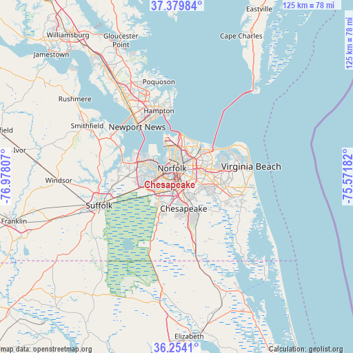
Chesapeake GPS coordinates[2]
36° 49' 8.544" North, 76° 16' 29.784" West
| Map corner | latitude | longitude |
|---|---|---|
| Upper-left | 37.37984°, | -76.97807° |
| Center: | 36.81904°, | -76.27494° |
| Lower-right: | 36.2541°, | -75.57182° |
| Map W x H: | 125.2×125.2 km | = 77.8×77.8mi |
| max Lat: | 71.29058° ⇑66.8% North |
| Chesapeake: | 36.81904° |
| min Lat: | ⇓33.2% South 19.06759° |
| min Long | Chesapeake | max Long |
| -171.73463° | -76.27494° | -66.98998° |
| W 83.2%⇐ | ⇒16.8% E |
Elevation
Elevation of Chesapeake is 9 m = 30 ft, and this is 285.8 m = 938 ft below average elevation for this country.
| Max E: |
3189 m = 10463 ft | 94.8% |
| Avg. | 294.8 m = 967 ft | |
| Chesapeake | 9 m = 30 ft | |
Min E: |
-60 m = -197 ft | 5.2% |
See also: Chesapeake elevation on elevation.city.
Geographical zone
Chesapeake is located in North temperate zone (between Tropic of Cancer and the Arctic Circle). Distance of this Northern Tropic circle is 1488 km =924.6 mi to South.| Distance of | km | miles | from Chesapeake |
|---|---|---|---|
| North Pole | 5913.2 | 3674.3 | to North |
| Arctic Circle | 3307.3 | 2055.1 | to North |
| Tropic Cancer | 1488 | 924.6 | to South |
| Equator | 4093.9 | 2543.8 | to South |


Nearby cities:
15 places around Chesapeake: (largest is in red/bold)
• Benns Church
30.7 km =19.1 mi,  295°
295°
• Carrollton
29.1 km =18.1 mi, 299°
• East Hampton
24.8 km =15.4 mi,  348°
348°
• Hampton
24.3 km =15.1 mi, 345°
• Isle of Wight
39.7 km =24.7 mi,  284°
284°
• Moyock
33.9 km =21.1 mi,  165°
165°
• Newport News
34.1 km =21.2 mi,  329°
329°
• Norfolk
3.2 km =2 mi,  343°
343°
• Poquoson
34.3 km =21.3 mi, 349°
• Portsmouth
2.8 km =1.7 mi,  311°
311°
• Portsmouth Heights
8.4 km =5.2 mi,  271°
271°
• Smithfield
36.5 km =22.7 mi, 299°
• South Suffolk
30.3 km =18.8 mi,  248°
248°
• Suffolk
29.4 km =18.3 mi, 249°
• Virginia Beach
26.7 km =16.6 mi,  81°
81°
Sources, notices
• [Note1] Compared only with cities in United States existing in our database
• [Src1] Map data: © OpenStreetMap contributors (CC-BY-SA)
• [Src2] Other city data from geonames.org with taken over terms of usage.
• [Src3] Geographical zone / Annual Mean Temperature by Robert A. Rohde @ Wikipedia
