Saluda geodata
Saluda (Virginia) is a seat of a second-order administrative division; located in United States in America/New_York (GMT-4) time zone. With population of 769 people, there are 18057 cities with bigger population in this country. Compared to other cities in United States, 63.6% of cities are located further ↑North; 82.2% of cities are located further ←West and 84.1% of cities have higher elevation than Saluda. Note1


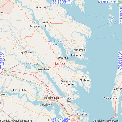
Saluda GPS coordinates[2]
37° 36' 21.492" North, 76° 35' 41.82" West
| Map corner | latitude | longitude |
|---|---|---|
| Upper-left | 38.16091°, | -77.29808° |
| Center: | 37.60597°, | -76.59495° |
| Lower-right: | 37.04685°, | -75.89183° |
| Map W x H: | 123.9×123.9 km | = 77×77mi |
| max Lat: | 71.29058° ⇑63.6% North |
| Saluda: | 37.60597° |
| min Lat: | ⇓36.4% South 19.06759° |
| min Long | Saluda | max Long |
| -171.73463° | -76.59495° | -66.98998° |
| W 82.2%⇐ | ⇒17.8% E |
Elevation
Elevation of Saluda is 31 m = 102 ft, and this is 263.8 m = 865 ft below average elevation for this country.
| Max E: |
3189 m = 10463 ft | 84.1% |
| Avg. | 294.8 m = 967 ft | |
| Saluda | 31 m = 102 ft | |
Min E: |
-60 m = -197 ft | 15.9% |
See also: United States elevation on elevation.city.
Geographical zone
Saluda is located in North temperate zone (between Tropic of Cancer and the Arctic Circle). Distance of this Northern Tropic circle is 1575.5 km =979 mi to South.| Distance of | km | miles | from Saluda |
|---|---|---|---|
| North Pole | 5825.7 | 3619.9 | to North |
| Arctic Circle | 3219.8 | 2000.7 | to North |
| Tropic Cancer | 1575.5 | 979 | to South |
| Equator | 4181.4 | 2598.2 | to South |


Nearby cities:
15 places around Saluda: (largest is in red/bold)
• Deltaville
23.4 km =14.5 mi,  104°
104°
• Gloucester Courthouse
22.6 km =14 mi,  164°
164°
• Gloucester Point
40.1 km =24.9 mi,  167°
167°
• Gwynn
29.3 km =18.2 mi,  112°
112°
• Heathsville
36.3 km =22.6 mi,  17°
17°
• Kilmarnock
22.2 km =13.8 mi,  58°
58°
• King William
38 km =23.6 mi,  283°
283°
• King and Queen Court House
25.9 km =16.1 mi,  285°
285°
• Lancaster
21.5 km =13.4 mi,  31°
31°
• Mathews
30.7 km =19.1 mi,  127°
127°
• New Kent
35.2 km =21.9 mi,  253°
253°
• West Point
19.6 km =12.2 mi,  244°
244°
• Williamsburg
38.6 km =24 mi,  194°
194°
• Williamsburg
39.2 km =24.4 mi,  199°
199°
• Yorktown
41.5 km =25.8 mi, 169°
Sources, notices
• [Note1] Compared only with cities in United States existing in our database
• [Src1] Map data: © OpenStreetMap contributors (CC-BY-SA)
• [Src2] Other city data from geonames.org with taken over terms of usage.
• [Src3] Geographical zone / Annual Mean Temperature by Robert A. Rohde @ Wikipedia
