Grafton geodata
Grafton (West Virginia) is a seat of a second-order administrative division; located in United States in America/New_York (GMT-4) time zone. With population of 5,148 people, there are 7044 cities with bigger population in this country. Compared to other cities in United States, 52% of cities are located further ↑North; 73.2% of cities are located further ←West and 75% of cities have lower elevation than Grafton. Note1


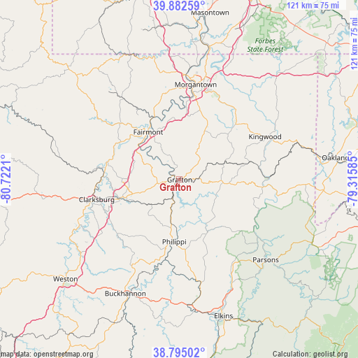
Grafton GPS coordinates[2]
39° 20' 27.312" North, 80° 1' 8.292" West
| Map corner | latitude | longitude |
|---|---|---|
| Upper-left | 39.88259°, | -80.7221° |
| Center: | 39.34092°, | -80.01897° |
| Lower-right: | 38.79502°, | -79.31585° |
| Map W x H: | 120.9×120.9 km | = 75.1×75.1mi |
| max Lat: | 71.29058° ⇑52% North |
| Grafton: | 39.34092° |
| min Lat: | ⇓48% South 19.06759° |
| min Long | Grafton | max Long |
| -171.73463° | -80.01897° | -66.98998° |
| W 73.2%⇐ | ⇒26.8% E |
Elevation
Elevation of Grafton is 313 m = 1027 ft, and this is 18.2 m = 60 ft above average elevation for this country.
| Max E: |
3189 m = 10463 ft | 25% |
| Grafton | 313 m 1027 ft | |
| Avg. | 294.8 m = 967 ft | |
Min E: |
-60 m = -197 ft | 75% |
See also: United States elevation on elevation.city.
Geographical zone
Grafton is located in North temperate zone (between Tropic of Cancer and the Arctic Circle). Distance of this Northern Tropic circle is 1768.4 km =1098.8 mi to South.| Distance of | km | miles | from Grafton |
|---|---|---|---|
| North Pole | 5632.8 | 3500.1 | to North |
| Arctic Circle | 3026.9 | 1880.8 | to North |
| Tropic Cancer | 1768.4 | 1098.8 | to South |
| Equator | 4374.3 | 2718.1 | to South |


Nearby cities:
15 places around Grafton: (largest is in red/bold)
• Anmoore
25.3 km =15.7 mi,  248°
248°
• Barrackville
22.1 km =13.7 mi,  324°
324°
• Bethlehem
23.2 km =14.4 mi,  284°
284°
• Bridgeport
21.3 km =13.2 mi, 253°
• Despard
25.4 km =15.8 mi,  256°
256°
• Enterprise
24 km =14.9 mi,  291°
291°
• Fairmont
19.2 km =11.9 mi,  326°
326°
• Monongah
21.8 km =13.5 mi,  308°
308°
• Paw Paw
25.8 km =16 mi, 333°
• Philippi
21.1 km =13.1 mi,  185°
185°
• Pleasant Valley
16.5 km =10.3 mi, 320°
• Reedsville
26.7 km =16.6 mi,  45°
45°
• Rivesville
22.6 km =14 mi,  338°
338°
• Shinnston
24.9 km =15.5 mi, 284°
• White Hall
16.7 km =10.4 mi,  302°
302°
Sources, notices
• [Note1] Compared only with cities in United States existing in our database
• [Src1] Map data: © OpenStreetMap contributors (CC-BY-SA)
• [Src2] Other city data from geonames.org with taken over terms of usage.
• [Src3] Geographical zone / Annual Mean Temperature by Robert A. Rohde @ Wikipedia
